
April picked up the warm weather that our record-breaking March left behind with abnormally high temperatures and low amounts of much needed precipitation. These high temperatures will continue to affect our snowpack and streamflow for the remainder of the spring and early summer months. Did we see our peak runoff for this year? This is a question that still has our local experts scratching their heads. Our reservoirs and soil moisture have been able to recharge early in the runoff season due to early snowmelt. There is still hope for the near future as weather model predictions change to support a wetter summer and fall with relatively warm temperatures during our typical monsoon season.
Temperature Trends
Our temperatures for late April have been showing trends of cooler patterns compared to what we saw in the record-breaking warm March reports. We are still breaking records in April with higher than average temperatures (figure1); however, a much needed cool and wet weather system fell on Colorado during the last week of April (figure 2) leading to slowing the snowpack melt, recharging soil moisture, and keeping streamflow relatively steady.

Figure 1: 30 Day Past Temperatures

Figure 2: 7 Day Past Temperatures
March and April were approximately 4°F warmer than the typical average. These above average temperatures have led to a much earlier budding season. Peter Goble, Assistant State Climatologist at the Colorado Climate Center, puts it plainly, “…bud break on trees and plants versus a normal year and most of the state was about three weeks early, if not even a little bit earlier” (figure 3).

Figure 3: Spring Leaf Index
Drought & Precipitation
Our eastern plains here in Colorado are climatologically dry from November through February, so the dry winter in the region alone does not cause alarm. However, March did not bring the much needed precipitation leading to significant drought degradation. Colorado’s Drought Task Force has entered their Phase 2 Drought Response Plan in response to the lack-luster precipitation and historically warm temperatures.
Similar to last month’s temperatures, precipitation in April has been historically dry with a much needed precipitation event during the last week of the month. Here in the Arkansas River Basin, precipitation averages are landing around 58% of median (figure 4). The April 1st and April 15th storms benefited southwest and western Colorado in regards to recharging snowpack, but these storms left the rest of the state yearning for more precipitation. These precipitation deficits are concerning, but and not as severe as the snowpack deficits.

As of April 28th, 98% of the state is in moderate drought, and 54% of the state is in severe to exceptional drought (figure 5). These extreme and exceptional drought conditions typically occur every 20 to 50 years. Over the last 12 weeks, portions of Colorado have seen three class worsening changes in their drought classifications as dry conditions continue.

Figure 5: U.S. Drought Monitor, Colorado
This time last year, the eastern plains were gearing up for a wetter than normal growing season. Because of the dry conditions this winter and spring, growing conditions are looking to be very dry. Producers in the eastern plains rely on spring storms ahead of planting season. The 90-day Standardized Precipitation Index (SPI) shows how rare this dryness is for this time of year (figure 6).

Figure 6: 90-day U.S. Gridded SPI
Snowpack
Colorado’s snowpack declined rapidly in March, but leveled out with April’s cooler temperatures. This year has broken records; our state’s lowest snowpack on record in the last 40 years of record is occurring now. Personally, this is history that I don’t want to live through, but it will be a great year to learn and grow from as our climate continues to change.
The snowpack in the Arkansas Basin is 13% of the median represented by the black line in the Snow Water Equivalent (SWE) graph (figure 7). Throughout the state, snow water equivalent is looking bleak with all of our major river basins below 32% of the median (figure 8). Typically for this time of year, we would have just experienced peak snowpack within the months of late March or early April; peak streamflow from this snowpack is typically the first week of June. This year, we are seeing almost the end of our snowpack and its associated runoff all within a three to four week window.


Figure 8: Snow Water Equivalent Colorado
We have only had a few good storms in Water Year 2026, most notably a wet October, one week of strong winter weather in January, and one day of heavy snow in February. This winter has just been one long, stable decline in precipitation from November through April while temperatures were increasing over the same time period.
Currently, only a few inches of SWE remain at high elevations. In Figure 8, we can see that the northern half of the state is holding on to more SWE compared to the southern half of the state. Late April brought back a much needed cool down helping the entire state try to hold on to what snow we still have left. The storm deposited snow at mid and high elevations. I watched the SWE graph rise from 9% in the Arkansas Basin to 13% from this single storm event. The Angel of Shavano, a prominent feature visible from Salida, lost her wings and grew them back all within the last seven days of April.
There is a small chance of our snowpack hanging on for a little while longer as long as we continue to hit freezing temperatures overnight. Our snowpack may stabilize, however our runoff recovery is unlikely to return to anywhere near average. Brian Domonkos with The U.S. Department of Agriculture says, “Is it possible that we could return to normal snowpack? There is a chance if we hold onto snow because temps are dropping below freezing overnight, but it is tough because our snowpack peaks were nowhere near normal so we won’t see that runoff.”
Soil Moisture
From warm temperatures leading to snowmelt, soil moisture has temporarily increased in all soil depths of 0-10cm and 0-1m (figures 9 and 10). Some especially warm areas in southern Colorado are seeing above normal soil moisture levels due to early snowmelt. The western half of our state is seeing dry soils at low elevations and wet soils at higher elevations. The eastern half of our state is experiencing below average soil moisture levels in low, mid, and high elevations. This degradation in soil moisture began about a month ago when March and April brought record high temperatures. Groundwater in the long run is seeing drying trends since our soil moisture at low elevations is relatively dry. In Colorado, we receive our water from snowpack and groundwater; both are looking low and dry in the big picture lens for this year.

Figure 9: Soil Moisture 0-10cm

Figure 10: Soil Moisture 0-1m
Streamflow
Streamflow in most basins of Colorado have likely already seen a peak around the third week of March. The Arkansas River’s Snow to Flow Plot is trending down, but remaining steady as April’s last week of cool weather has provided some stability (figure 11). It’s hard to say if we will see another peak since our snowpack state-wide is looking slim. Brian Domonkos agrees, “there is a chance in some basins that streamflow has already peaked. We are at least halfway through the melt-off.” The remaining flows to trickle down the mountains and hills will likely retain a consistent streamflow for a few more weeks to come with little chances of an increase in flow.
This year resembles 2002 with a weak and prolonged runoff rather than a typical high-flow peak. During the Arkansas Basin’s Water Forum, U.S. Geological Survey teams measuring streamflow at Nathrop and Parkdale gauges were afraid they missed measurements of peak for the 2026 season. The USGS gauges are active from April 1st to September 1st. This is the first time in an estimated 75 years that peak flow has not fallen within this timeframe.
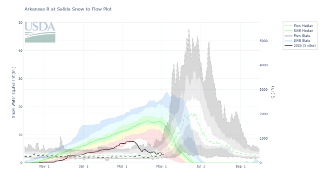
Figure 11: Arkansas River at Salida Snow to Flow Plot
Streamflow Snapshot (5/5/2026; 11:00 am)
* measured flow totals include native flows, BOR project water, releases, and exchanges
Granite, CO (8 miles south of Leadville)- 210 cfs
Salida, CO- 271 cfs
Wellsville, CO- 300 cfs
Parkdale, CO (8 miles west of Cañon City)– 319 cfs
Portland, CO (10 miles south of Cañon City)– 156 cfs
Pueblo, CO (Below Pueblo Reservoir)- 70 cfs
Avondale, CO- 429 cfs
Lamar, CO- 37 cfs
For current streamflow updates, reference the Colors of Water webpage.
Reservoir Storage
Reservoir storage in the Arkansas River Basin is at 49% capacity (394.1kaf) which will help cushion the impact of a historically dry and warm winter and spring (figure 12). This time last year, reservoirs in the Arkansas River Basin were at 57% capacity (452.2 kaf) which is surprisingly similar to this years’ reservoir capacities.

Figure 12: Reservoir Storage in Colorado
Reservoir Snapshot (5/5/2026; 11:00 am)
Clear Creek Reservoir: 71%
Lake Henry: 82%
Meredith Reservoir: 92%
Pueblo Reservoir: 61%
Trinidad Lake: 12%
Turquoise Lake: 53%
Twin Lakes Reservoir: 42%
For current reservoir updates, reference the interactive Reservoir Plots webpage.
Seasonal Outlook
In the near future, weather models are showing a pressure shift bringing cooler northern air and an increased chance of moisture. As cooler conditions are likely to return in May, Peter Goble remains hopeful, “for as non-snowy as it has been, I think we could see May snow based on the pressure shift.” Compared to last month’s forecasts, we are looking at slightly cooler temperatures and more hopeful precipitation outlooks. This may sound promising but our forecasted temperatures are still looking above normal (figure 14) and our forecasted precipitation is still below normal (figure 13). These three month forecasts can help us gauge what streamflow and soil moisture could look like in a drought stricken year (figure 15).

Figure 13: Three Month Precipitation Outlook

Figure 14: Three Month Temperature Outlook

Figure 15: U.S. Seasonal Drought Outlook
The El Niño-Southern Oscillation (ENSO) transition has turned from a La Niña winter into a probable El Niño summer. The chances of El Niño reaching us by early summer is about a 60% chance and greater than a 90% chance by fall (figure 16). This coming El Niño could become a super El Niño (greater than 2°C) as some dynamic models suggest; super El Niños statistically correlate with higher precipitation. Peter Goble makes the analogy, “it’s like playing poker with a few extra aces and kings in the deck. The odds may be stacked in your favor, but you could still draw a crummy hand.”

Figure 16: ENSO Probabilities
Looking at our wildfire risk this season, it may not be a surprise to hear that wildfire risk is elevated following the warm, dry winter we experienced (figure 17). These potential wildfires, along with a strong monsoon season, could lead to an increased chance of severe floods later in the summer season especially in areas surrounding fresh burn scars.

Figure 17: Wildland Fire Potential Outlook
Want to Learn More? Check out these resources below!
Monitoring
Drought Monitoring: US Drought Monitor
Drought Forecast: National Weather Service Climate Prediction Center
Precipitation Totals: Community Collaborative Rain, Snow, and Hail Network’s Precipitation Mapping System.
Snowpack: Natural Resources Conservation Service
Winter Water Storage System (only applicable until March): Southeastern Colorado Water Conservancy District
Precipitation: https://www.cocorahs.org/
Arkansas River Daily Report – http://www.div2waterops.com/dailyreports
Arkansas Streamflow: http://www.div2waterops.com/ColorsOfWater
Snow Survey and Water Supply Forecasting: Natural Resource Conservation Service Snow Survey
Additional monitoring resources:
Colorado Water Conservation District/Department of Natural Resources
Definitions
30 Year Running Average: When we present the monthly flows, we compare them to that month’s median flows from the last 30 years (referred to as 30 year running average).
Reservoir Percent Full: The Bureau of Reclamation considers a reservoir “full” when pool elevation is at the top of the active conservation pool. Percentage is therefore based on total reservoir volume below that level.
Educational Resources
Administrative Call Explained: DWR
Citizen’s Guide to Colorado Water Law: CFWE Education
Non-Attorney’s Guidebook to Colorado Water Courts: Co State
Voluntary Flow Management
- https://arkvalleyvoice.com/ahra-says-arkansas-river-flows-are-high-and-fast-making-safety-paramount/
- https://coloradotu.org/arkansas-river
U.S. Climate Normals: https://www.ncei.noaa.gov/products/land-based-station/us-climate-normals
