
A mid-March heat wave hit the Western US and here in Colorado, it has taken a serious toll on the state’s snowpack across all elevations (figure 1). Throughout this warm, dry winter, experts have been studying other historically comparable years to inform water supply planning, wildfire mitigation efforts, and more, but as we move into spring with a week of summery temperatures, Brad Udall, Senior Water and Climate Research Scientist, puts it plainly:
“There is no historical analogue to this.”

Temperature Trends
For most of Colorado, March brought the hottest temperatures ever recorded for the month, with more locations breaking records than not (Figure 2). The period from March 18–21 saw the highest temperatures, but even the first half of the month averaged more than 6°F above normal statewide (figure 3).
March is not the only month setting records this water year. It follows the warmest February on record and the warmest winter (December–February) recorded since 1895. Day-to-day temperatures have remained above normal for much of the water year.
The effects of this heat are visible across the basin and the state. The Spring Leaf Index shows trees leafing out more than three weeks earlier than average, wildfires are already emerging, and snowpack levels have plummeted.

figure 2: March Temperature Records Broken

Drought & Precipitation
On March 18, Governor Jared Polis activated the Colorado Drought Task Force in response to record heat and low snowpack across the state. Officials from multiple agencies will collaborate to assess drought conditions, gather and analyze data, and provide resources to impacted communities statewide. The goal is to enhance preparedness and ensure coordinated support at both the state and local levels. The activation of the Drought Task Force moves Colorado into the second phase of its Drought Response Plan. Should conditions worsen, the state may advance to phase three, which would involve a formal drought declaration.
The US Drought Monitor shows drought conditions are worst in the Northwestern corner of Colorado, but severe drought has taken hold of most of the Western portion of the state (figure 4).

figure 4: Colorado Drought Monitor
Currently, most of the state of Colorado is at 100% Evaporative Demand (figure 5). The Evaporative Demand Drought Index (EDDI) is an experimental tool designed to monitor and provide early warning of drought by measuring how unusually high the atmosphere’s demand for moisture is over different time periods. Because it can assess conditions from weekly to yearly scales, it helps detect both short-term “flash” droughts and longer-term dry spells. Updated daily (with a short lag for data quality control), EDDI supports preparedness for agricultural impacts, water supply concerns, and elevated wildfire risk across the U.S. and parts of Canada and Mexico.

figure 5: Evaporative Demand Drought Index
Snowpack
Through my office window in Salida, CO, the Collegiate Range looks like it typically does in early July. The Angel of Shavano couloir has shriveled to a skeleton, and the peaks have shed their winter white to reveal granite-gray summits. According to SNOTEL site data, the Arkansas River Basin’s snow-water equivalence (SWE) is just 11% of average for this time of year (figure 6). Over the last few weeks of unseasonably warm weather, SWE has been plummeting as Colorado’s snowpack has prematurely become isothermal, meaning the entire snow layer has reached 0°C (32°F), is actively melting, and is structurally unstable (figure e). This early shift to an isothermal state threatens to accelerate spring runoff.
The last two weeks of March have taken a serious toll on snowpack across all elevations, with SNOTEL sites losing several percentage points of SWE per day. While there has been a slight increase in streamflow, it is minimal and may already represent peak flow. Much of the snow is disappearing without translating into high river flow, indicating that the dry soil moisture is absorbing much of the runoff before it makes it to the rivers.

figure 6: Percent of Median Snow-Water Equivalence

figure 6: Percent of Normal Precipitation
March Precipitation Totals
Leadville-0.45″
Buena Vista-0.91″
Salida-0.40″
Cañon City-1.48″
Pueblo -0.68”
Lamar-0.00″
Soil Moisture
Soil moisture levels are currently above normal at higher elevations, largely due to early snowmelt boosting moisture in the mountains (figure 7). In contrast, lower elevations are experiencing below-normal soil moisture, driven by a dry winter that left soils parched heading into spring. Broader measures of terrestrial water storage, which include groundwater, soil moisture, snowpack, and canopy moisture, show some of the lowest levels on record for this time of year across much of the state (figure 8). Groundwater, in particular, has declined over time, with the data record for this product dating back to the early 2000s.

figure 7: One Meter Soil Miosture

figure 8: Terrestrial Water Storage
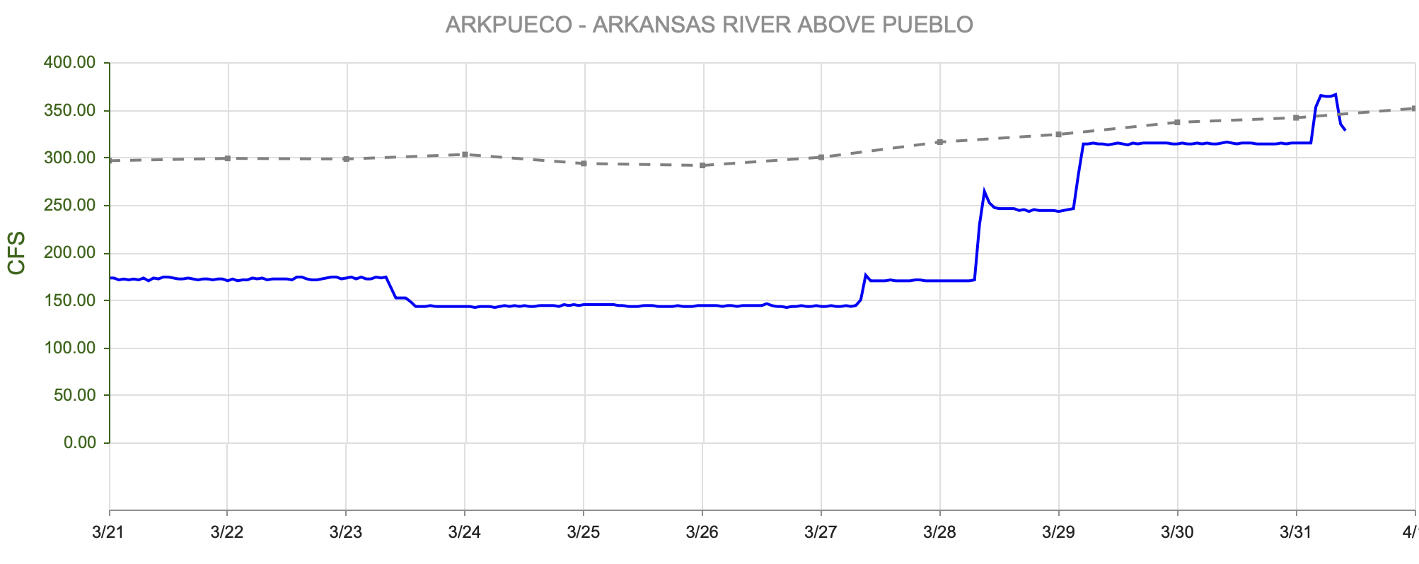
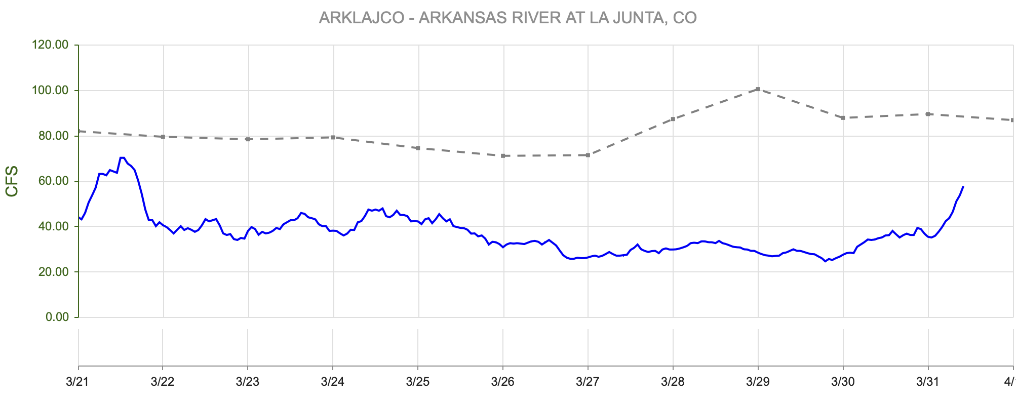
Streamflow
The Natural Resources Conservation Service (NRCS) is forecasting below-normal streamflow across Colorado’s major basins, with most Arkansas River sites expected to receive less than 50% of average runoff, some as low as 27%. Persistent warm and dry conditions are also expected to push peak runoff earlier than the historical average.
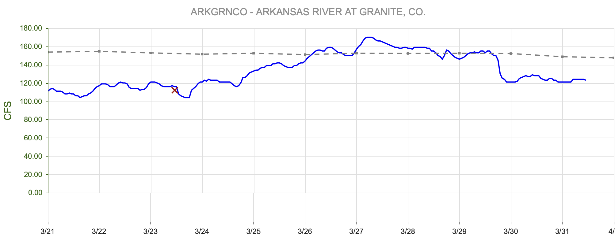
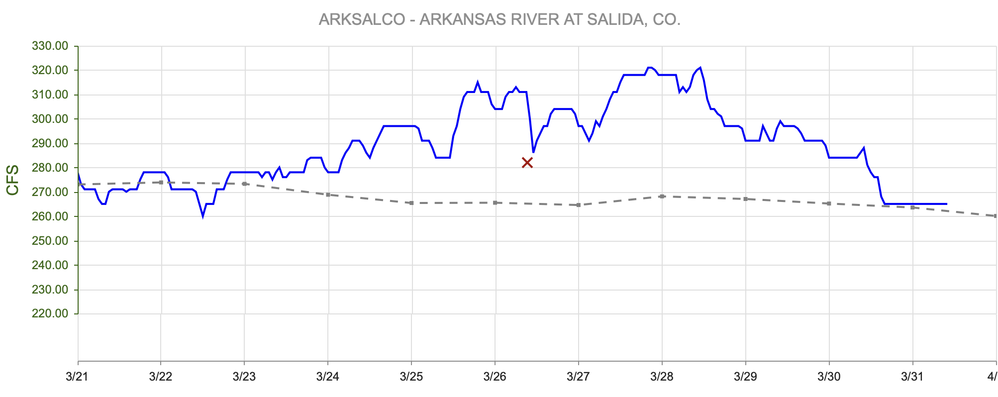
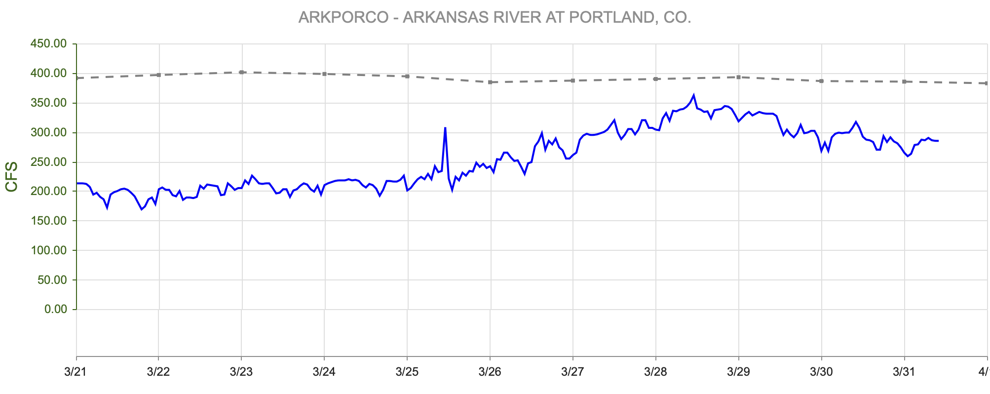
As of late March, streamflow remains near average for this time of year, largely driven by early-season snowmelt (figure 9; 10). However, water managers caution that peak flows may arrive soon, with declines likely to be felt acutely by early summer (figure 11). As a result, summer on the Arkansas River may look different this year.
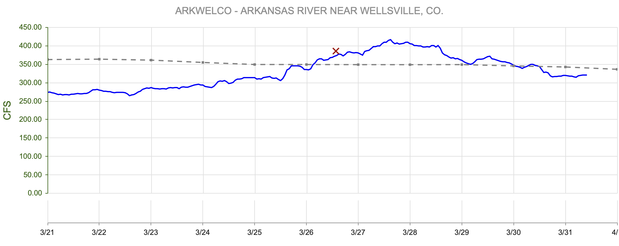


The Voluntary Flow Management Program, a cooperative effort to manage and augment flows on the Arkansas River to enhance non-consumptive recreational uses such as fishing and rafting, will continue to operate. However, with limited available water, partners do not expect to meet the typical summer target of 700 cubic feet per second (cfs) at the Wellsville gauge between July 1 and August 15—a level often considered a “fun flow.” They will, however, do their best to maintain flows that protect fisheries and allow rafting outfitters to continue running trips.
Dry conditions also directly affect the fishery below Pueblo Dam. Despite Lake Pueblo State Park appearing full, downstream calls on the river are already being made. The Low Flow Program, established in the 1990s, requires that if flows drop below 50 cfs approximately one mile below Pueblo Dam, either Colorado Springs or Pueblo must release enough water to maintain 50 cfs at the fish hatchery downstream. This program is triggered frequently in dry years and will likely come into play again this year.
With a limited water supply, additional management actions, including potential fishery closures, remain on the table. As Rena Griggs, Colorado Parks and Wildlife’s Southeast Region Water Specialist, puts it, “In a dry year, flexibility goes away.”
Streamflow Snapshot (4/1/2026; 12:00 pm)
* measured flow totals include native flows, BOR project water, releases, and exchanges
Granite, CO (8 miles south of Leadville)- 122 cfs
Salida, CO- 263 cfs
Wellsville, CO- 316 cfs
Portland, CO (10 miles south of Canon City)- 262 cfs
Pueblo, CO- 335 cfs
Avondale, CO- 659 cfs
Lamar, CO- 50 cfs
For current streamflow updates, reference the Colors of Water webpage.
Reservoir Storage
The winter of 2026 has often been compared to 2002, another historically dry winter that is still recent enough for many to remember. Fortunately, we learned from the 2002 drought and lower Arkansas River reservoirs are currently in better condition than they were during the 2002 drought, providing some buffer against dry conditions (figure 12). Many municipalities also took advantage of wet years after 2002 to build up water supplies, which provides some buffer but also raises a key question for water managers: “How many years of resilience do we have built into our systems?” — Alan Ward, Water Resources Division Manager at Pueblo Water.

figure 12: Reservoir Storage Compared to 2025

figure 13: Reservoir Storage Percent of Median
Seasonal Outlook
The winter of 2025–2026 featured a weak La Niña, which has largely dissipated, and neutral conditions are expected to persist through the spring. There is roughly a 60% chance that an El Niño will develop by fall. La Niña winters and springs are typically associated with dry, windy conditions in Colorado, so while the weakening of La Niña is somewhat favorable, dry conditions may still continue through spring. The seasonal outlook indicates an increased probability of above-normal temperatures and below-normal precipitation in the coming months. On a more hopeful note, some models suggest the potential for wetter conditions later in the summer, including the possibility of a stronger monsoon season.

figure 13: Three Month Temperature Outlook

figure 14: Three Month Precipitation Outlook

figure 15: Seasonal Drought Outlook

figure 16: ENSO Predictions
Want to Learn More? Check out these resources below!
Monitoring
Drought Monitoring: US Drought Monitor
Drought Forecast: National Weather Service Climate Prediction Center
Precipitation Totals: Community Collaborative Ran, Snow, and Hail Network’s Precipitation Mapping System.
Snowpack: Natural Resources Conservation Service
Winter Water Storage System (only applicable until march): Southeastern Colorado Water Conservancy District
Precipitation: https://www.cocorahs.org/
Arkansas River Daily Report – http://www.div2waterops.com/dailyreports
Arkansas Streamflow: http://www.div2waterops.com/ColorsOfWater
Snow Survey and Water Supply Forecasting: Natural Resource Conservation Service Snow Survey
Additional monitoring resources:
Colorado Water Conservation District/Department of Natural Resources
Definitions
30 Year Running Average: When we present the monthly flows, we compare them to that month’s median flows from the last 30 years (referred to as 30 year running average).
Reservoir Percent Full: The Bureau of Reclamation considers a reservoir “full” when pool elevation is at the top of the active conservation pool. Percentage is therefore based on total reservoir volume below that level.
Educational Resources
Administrative Call Explained: DWR
Citizen’s Guide to Colorado Water Law: CFWE Education
Non-Attorney’s Guidebook to Colorado Water Courts: Co State
Voluntary Flow Management
- https://arkvalleyvoice.com/ahra-says-arkansas-river-flows-are-high-and-fast-making-safety-paramount/
- https://coloradotu.org/arkansas-river
U.S. Climate Normals: https://www.ncei.noaa.gov/products/land-based-station/us-climate-normals
