")
Compared with the record warmth of this past winter, conditions in late April and May moderated. Temperatures remained above normal, but much-needed precipitation arrived during the last weeks of April and the first weeks of May. October through April were dry across much of the state, particularly the eastern plains, which received less than 50% of normal precipitation for that period. Water Year 2026 stands out as both exceptionally warm and exceptionally dry; most prior water years fall into milder warm-or-dry categories rather than reaching both extremes at once (figure 1).
May brought more precipitation than the preceding months. March averaged roughly 10°F above the 30-year average, while April was about 2°F above it. Across Water Year 2026, daily temperatures have generally run warmer than the 30-year average, with substantial day-to-day variability (figure 2).
Drought conditions have eased modestly since the previous report, and basin reservoir storage continues to provide a buffer against the dry year (see Reservoir Storage, figure 15).


Temperature Trends
On a daily-average basis, April ranked among the 10th to 35th warmest on record across most of the state with western Colorado experiencing near-normal temperatures. This remained well above normal, though not as extreme as March. May continued the warm and dry pattern set by the winter and spring. During the last week of May, southern Colorado saw near-normal temperatures (figure 3).

Figure 3: 7 Day Departure from Normal Temperature
Drought & Precipitation
Much of the state improved by at least one drought class since last month’s report (figure 4). Over the past 30 days, most of Colorado received 0.01 to 3.98 inches of precipitation while northern Colorado received 3.99 to 6.68 inches, enough to improve drought classifications one to three classes in certain areas (figure 5).
Statewide, the drought monitor remains broadly similar to recent months, with Colorado still in moderate to severe drought (figure 6).

Figure 4: U.S. Drought Monitor Class Change

Figure 5: 30 Day Precipitation Totals

Figure 6: U.S. Drought Monitor
Snowpack
Snowpack in the Arkansas River Basin is at 13% of average (figure 7). May precipitation events delivered roughly two feet of snow to select areas of the basin, prolonging the snowpack by several weeks.
Snow water equivalence (SWE) is no longer the lowest on record. Between May 4th and May 6th, basin SWE surpassed the 2002 levels, making Water Year 2026 the second-lowest snowpack on record (figure 8). The main differences between 2002 and 2026 are the rate of melt and average snowpack depth. Water Year 2026 saw less total precipitation than Water Year 2002, but retained its snow through May.

Figure 7: Snow Water Equivalent Average

Precipitation
Northern Colorado received more precipitation than the southern half of the state (figure 9) contributing to drought classification improvements noted above (figure 4). Eastern and south-eastern Colorado recorded above average precipitation for May though additional precipitation is still needed statewide to move out of the current drought (figure 10).

Figure 9: 30 Day Colorado Precipitation

Figure 10: May 2026 Average Precipitation
Soil Moisture
Soil Moisture across the state has remained relatively stable with snowmelt allowing soil-moisture recharge to occur earlier than in a typical year. At depths of 0-10 cm, soil moisture is approximately 0.30 by volume (figure 11); at depths of 0-1 m, it averages 0.15-0.20 by volume (figure 12).

Figure 11: Soil Moisture 0-10cm

Figure 12: Soil Moisture 0-1m
Streamflow
Several spring storms brought snow to parts of the basin in late April (the 2nd, 15th, and 27th) and again in May (the 1st, 7th, and 20th) adding to the snowpack in those areas and prolonging it by a few weeks. At the Salida gauge, the Arkansas River recorded two streamflow peaks: 382 cfs on May 16 and 364 cfs on May 29 (figure 13). With basin snowpack now at 13% of average and little additional snow expected, the May 16 peak at Salida likely represents the seasonal snowmelt peak at that location.
As in prior years, summer convection storms and the monsoon can produce localized flash flooding later in the season, particularly near recent burn scars.
Streamflow in the upper Arkansas River is steady, driven largely by native flow (figure 14). Below Pueblo Reservoir, releases are currently running well above the roughly 70 cfs associated with the downstream fishery’s low-flow target.
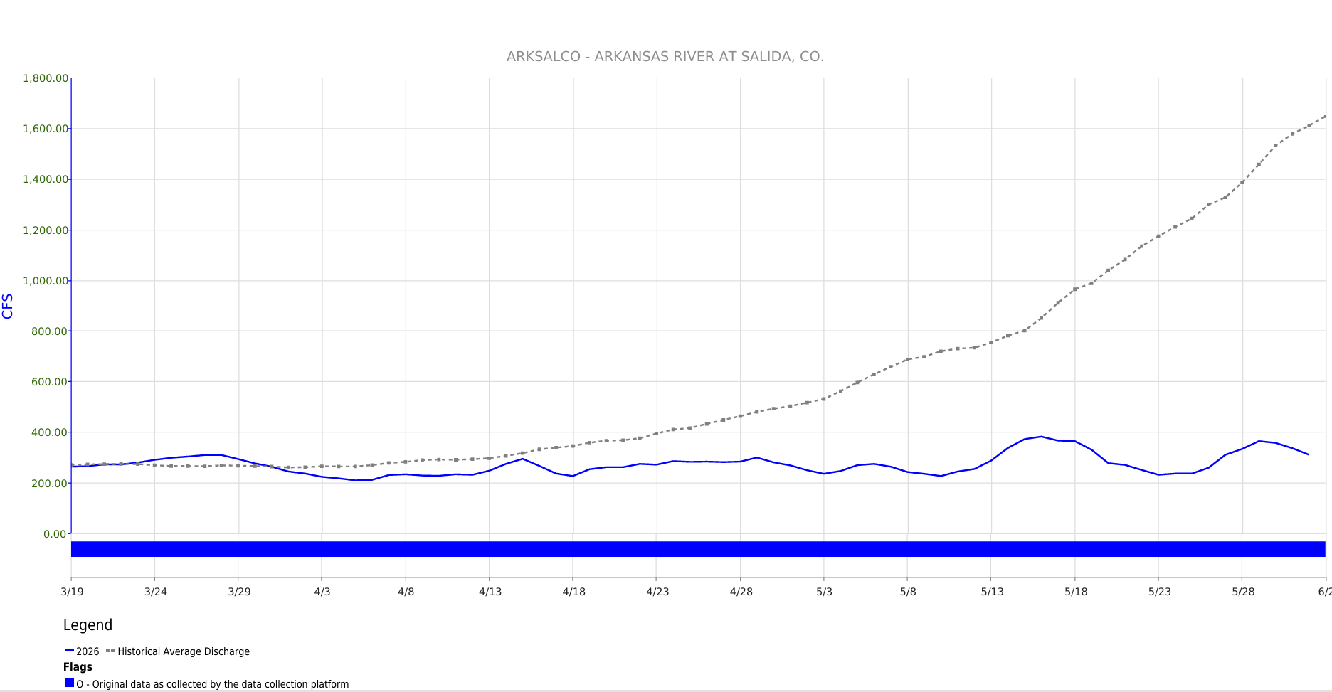
Figure 13: Streamflow Arkansas River at Salida, CO
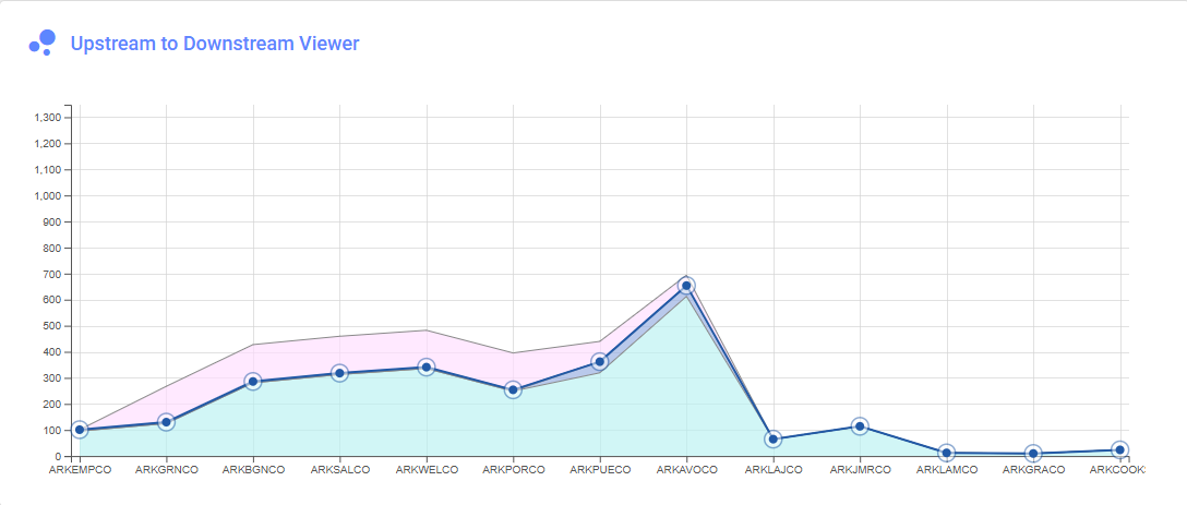
Streamflow Snapshot (6/2/2026; 11:45 am)
* measured flow totals include native flows, BOR project water, releases, and exchanges
Granite, CO (8 miles south of Leadville)- 287 cfs
Salida, CO- 316 cfs
Wellsville, CO- 338 cfs
Parkdale, CO (8 miles west of Cañon City)– 354 cfs
Portland, CO (10 miles south of Cañon City)– 266 cfs
Pueblo, CO (Below Pueblo Reservoir)- 367 cfs
Avondale, CO- 643 cfs
Lamar, CO- 11.6 cfs
Holly, CO (near CO/KS border)- 11.6 cfs
For current streamflow updates, reference the Colors of Water webpage.
Reservoir Storage
Reservoir storage in the basin reflects active management for current conditions. Since last month, Clear Creek Reservoir has drawn down substantially while the basin-wide storage rose; water was moved downstream from Clear Creek Reservoir to allow repairs to the dam, which are intended to prevent losses from aging infrastructure. Basin-wide storage stands at 55%, or about 350 kaf (figure 15).

Figure 15: Arkansas River Basin Reservoir Storage
Reservoir Snapshot (6/2/2026; 12:45 am)
Clear Creek Reservoir: 17%
Lake Henry: 71%
Meredith Reservoir: 62%
Pueblo Reservoir: 56%
Trinidad Lake: No Data Available
Turquoise Lake: 71%
Twin Lakes Reservoir: 32%
For current reservoir updates, reference the interactive Reservoir Plots webpage.
Seasonal Outlook
Precipitaion
The precipitation outlook remains favorable; forecasts call for 0.10 to 0.50 inches of precipitation within the next week (figure 16). The 8-14 day outlook places Colorado at a slightly above-average chance of precipitation (figure 17), consistent with prediction models showing a developing El Niño pattern (figure 18). At a seasonal scale, Colorado has an above-average chance of precipitation this summer (figure 19).

Figure 16: 7-Day Precipitation Forecast

Figure 17: 8-14 Day Precipitation Outlook

Figure 18: ENSO Forcased Probabilities

Figure 19: Seasonal Precipitation Outlook
Temperature
Temperature forecasts across the state, for both the 8-14 day and seasonal outlooks are consistently above average (figure 20 and 21, respectively).

Figure 20: 8-14 Day Temperature Outlook

Figure 21: Seasonal Temperature Outlook
Wildfire Risk
The wildfire outlook is similar to last month’s report, with significant wildland fire potential across western Colorado and much of the western U.S. (figure 22). This above-average risk is expected to persist through the end of August.

Drought Outlook
The drought outlook has shifted slightly from last month (figure 23). Moderate precipitation in late May reduced the amount of drought development expected in northern Colorado and prompted the drought-class changes noted above (figure 4). Drought is likely to persist across Colorado and much of the western U.S.

Figure 23: U.S. Seasonal Drought Outlook
Want to Learn More? Check out these resources below!
Monitoring
Drought Monitoring: US Drought Monitor
Drought Forecast: National Weather Service Climate Prediction Center
Precipitation Totals: Community Collaborative Rain, Snow, and Hail Network’s Precipitation Mapping System.
Snowpack: Natural Resources Conservation Service
Winter Water Storage System (only applicable until March): Southeastern Colorado Water Conservancy District
Precipitation: https://www.cocorahs.org/
Arkansas River Daily Report – http://www.div2waterops.com/dailyreports
Arkansas Streamflow: http://www.div2waterops.com/ColorsOfWater
Snow Survey and Water Supply Forecasting: Natural Resource Conservation Service Snow Survey
Additional monitoring resources:
Colorado Water Conservation District/Department of Natural Resources
Definitions
30 Year Running Average: When we present the monthly flows, we compare them to that month’s median flows from the last 30 years (referred to as 30 year running average).
Reservoir Percent Full: The Bureau of Reclamation considers a reservoir “full” when pool elevation is at the top of the active conservation pool. Percentage is therefore based on total reservoir volume below that level.
Educational Resources
Administrative Call Explained: DWR
Citizen’s Guide to Colorado Water Law: CFWE Education
Non-Attorney’s Guidebook to Colorado Water Courts: Co State
Voluntary Flow Management
- https://arkvalleyvoice.com/ahra-says-arkansas-river-flows-are-high-and-fast-making-safety-paramount/
- https://coloradotu.org/arkansas-river
U.S. Climate Normals: https://www.ncei.noaa.gov/products/land-based-station/us-climate-normals
