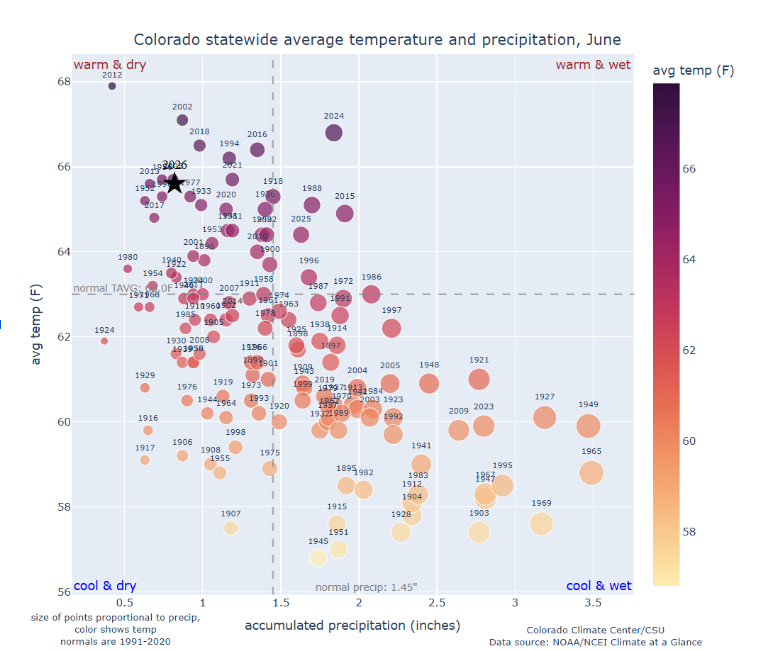
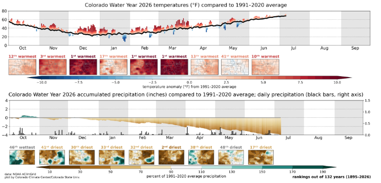
The governor has declared a drought emergency and the state is now in Phase 3 of the drought response plan. Looking at the statewide average temperature and precipitation in June, we are still looking at historically warm and dry conditions, but we are no longer setting records compared to other June statistics like in 2012, 2002, 2018, 1994, and 2016 (figure 1). May saw the 41st warmest and 48th driest month on record and June landed as the 10th warmest and 17th driest on record (figure 2). Colorado’s Water Year 2026 is the warmest first eight months in 131 years of record, 5.1F warmer than the 1991-2020 average, 1.7F warmer than the previous record (WY 1934).
Temperature Trends
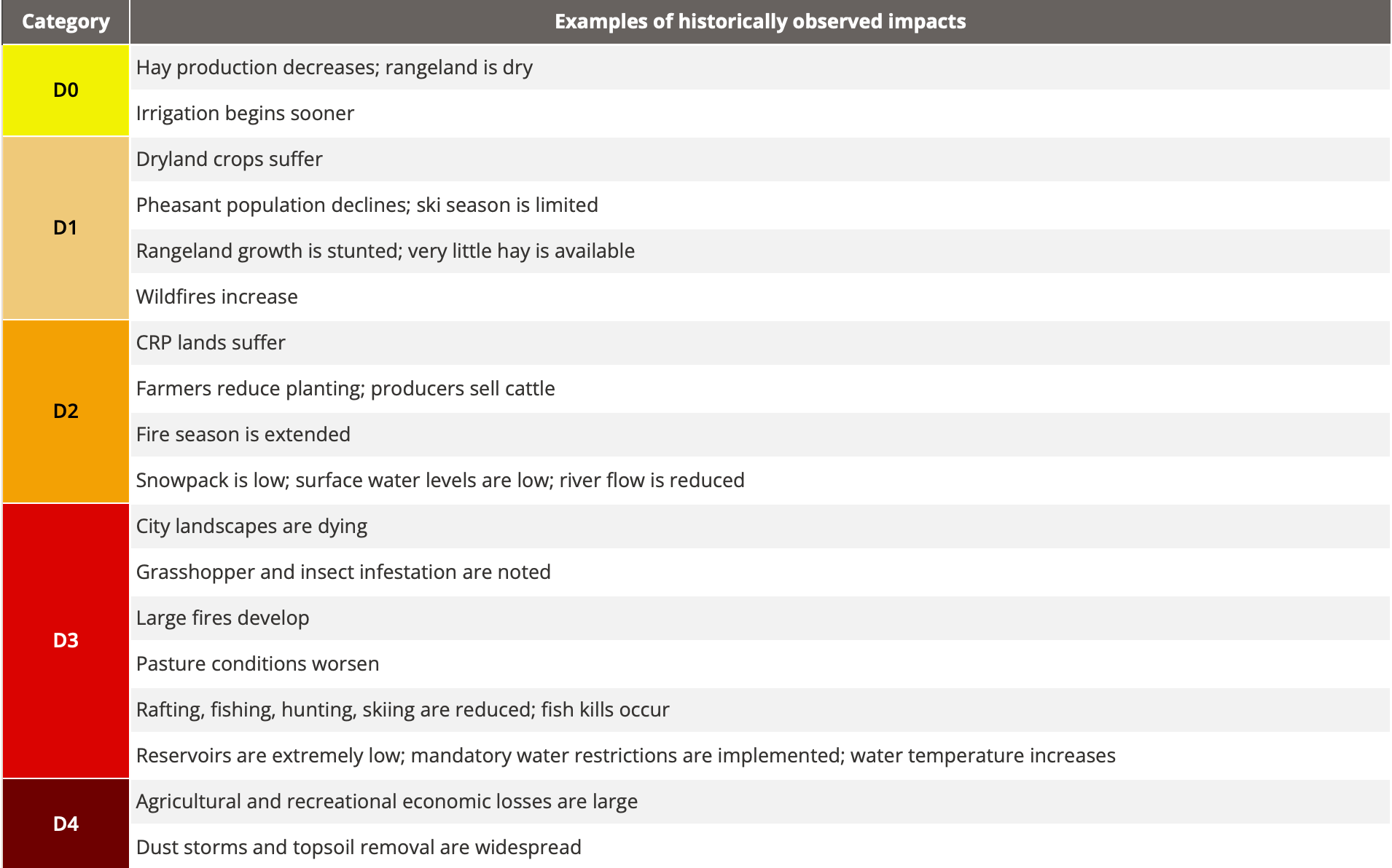
The current water year is the warmest on record for the first eight months and among the top 10 driest (figure 2). While May saw near-average temperatures and some beneficial rain, the overall long-term trend remains extremely concerning, with widespread D3 (Extreme) and D4 (Exceptional) drought conditions (figure 4). Temperatures in June were also much warmer than the typical average being 1 to 4F warmer (figure 3). After a string of extremely warm months, temperatures in May and June 2026 were much closer to the long-term average.
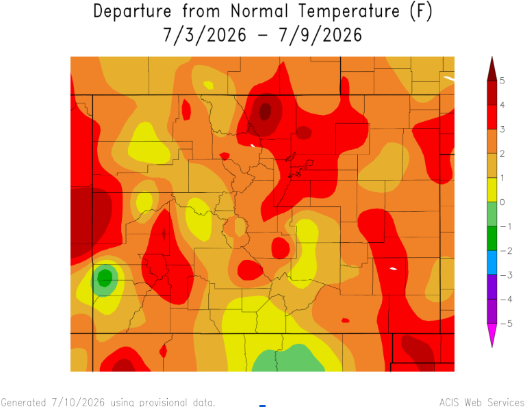
Figure 3: 7 Day Departure from Normal Temperature
Drought & Precipitation
Colorado has not seen a significant change in our drought classifications compared to last month. 95% of the state is experiencing drought D1 conditions or worse, 75% in severe drought (D2), a third of the state in D3 or worse, and 9% in D4 (figure 4). Colorado has seen some significant rainfall in the eastern plains (figure 5) which has led to a drought class improvement. The rest of the state has not seen enough significant rainfall which has led to at least one drought class degradation (figure 6). Statewide, Water Year 2026 is the 7th driest start to a water year. Dry areas across the state have been the central mountains, northeastern plains, and parts of southern Colorado (figure 4). Our recent precipitation has not improved the drought conditions, but the precipitation has kept the drought conditions from getting worse (figure 6).
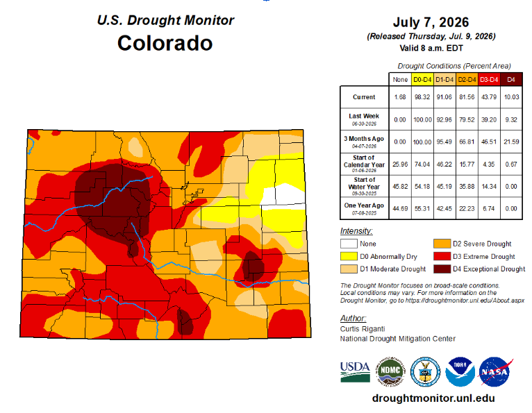
Figure 4: U.S. Drought Monitor, Colorado
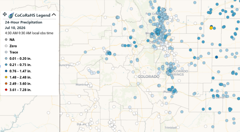
Figure 5: 30 Day Precipitation Totals
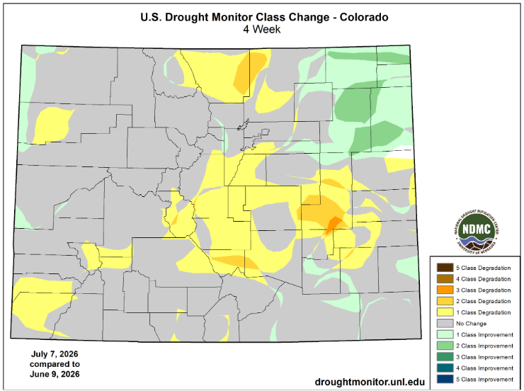
Figure 6: U.S Drought Monitor 4 Week Class Change
Snowpack
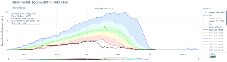
The statewide snowpack is at 8% of the median, with peak runoff occurring several weeks earlier than usual. Here in the Arkansas River Basin, SWE is trending to be the second lowest on record behind 2002 (figure 7).
Precipitation
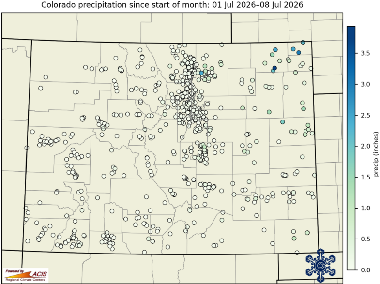
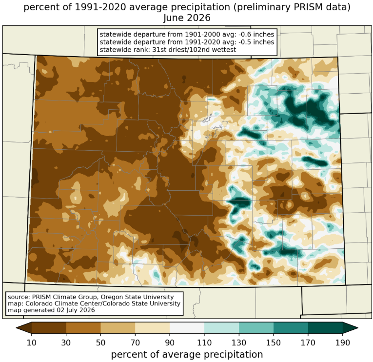
Precipitation over May and June have been below average for much of the state. The eastern plains have seen above average precipitation from the thunderstorm season (figure 8 & 9).
Soil Moisture
Soil moisture in the 10cm and 1m depth range is historically dry (figure 10 & 11). Shallow soil moisture in the high county is poor along with parts of the western slope and eastern plains (figure 10). Deep soil moisture is poor across the state except for areas that received heavy rain in the last month (figure 11).
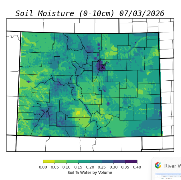
Figure 10: Soil Moisture 0-10cm
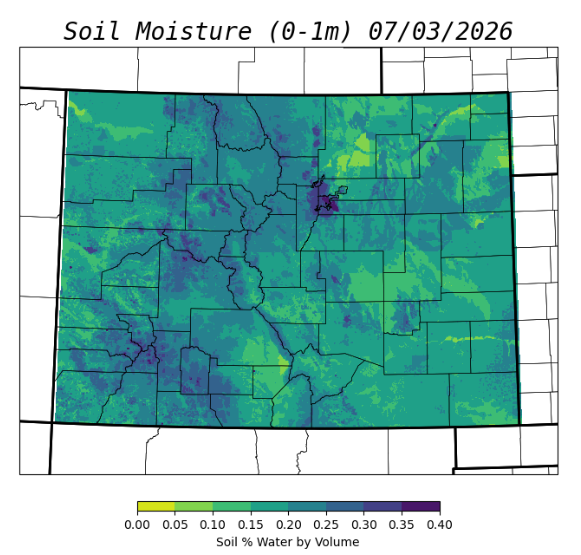
Figure 11: Soil Moisture 0-1m
Evaporative Demand
Evaporative demand over the last month has been high but not extreme (figure 12). Eastern Colorado has received beneficial rainfall and cloud coverage during this thunderstorm season. If we zoom out to a six month lens, the evaporative demand has been extremely high for the entire state (figure 13).
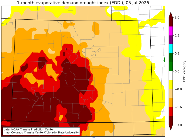
Figure 12: 1-Month Evaporative Demand Drought Index
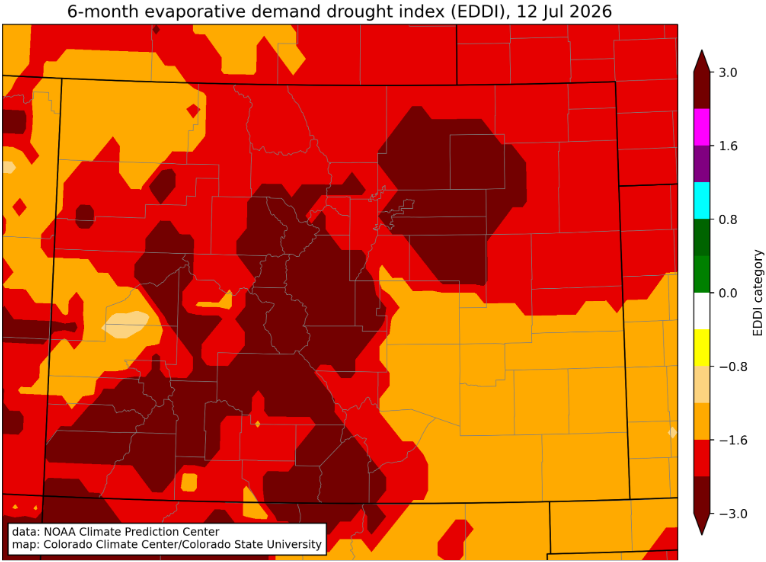
Figure 13: 6-Month Evaporative Demand
Streamflow
Rivers across Colorado have experienced record low streamflow. The Arkansas River Basin has set records that were previously set by the 2002 Water Year. Flows in the Arkansas River have been steadily decreasing (figure 14). Forecasts show a potential streamflow peak from flooding with promising monsoon season forecasts typically beginning in late July and early August.
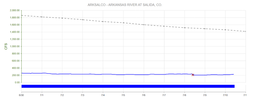
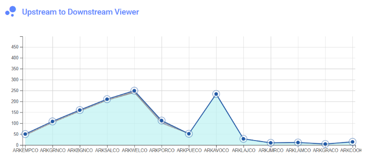
Streamflow Snapshot (7/28/2026; 3:25 pm)
* measured flow totals include native flows, BOR project water, releases, and exchanges
Granite, CO (8 miles south of Leadville)- 283 cfs
Salida, CO- 310 cfs
Wellsville, CO- 331 cfs
Parkdale, CO (8 miles west of Cañon City)– 262 cfs
Portland, CO (10 miles south of Cañon City)– 145 cfs
Pueblo, CO (Below Pueblo Reservoir)- 22.5 cfs
Avondale, CO- 208 cfs
Lamar, CO- 26.4 cfs
Holly, CO (near CO/KS border)- 19.8 cfs
For current streamflow updates, reference the Colors of Water webpage.
Reservoir Storage
Forecasts for streamflow remain significantly below median levels, and reservoir storage is currently at 75% of the statewide median (figure 16 & 17). The Arkansas River Basin’s reservoir storage is relatively healthy compared to the state average sitting at 91% (figure 17).
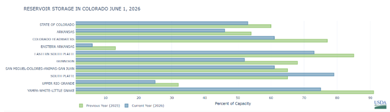
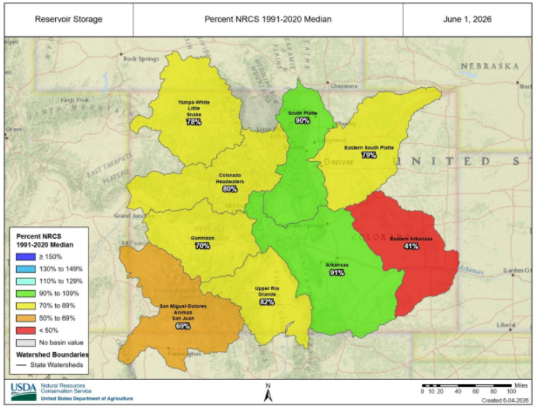
Figure 17: Colorado Reservoir Storage
Reservoir Snapshot (7/28/2026; 3:35 pm)
Clear Creek Reservoir: 17%
Lake Henry: 71%
Meredith Reservoir: 62%
Pueblo Reservoir: 56%
Trinidad Lake: 10%
Turquoise Lake: 71%
Twin Lakes Reservoir: 32%
For current reservoir updates, reference the interactive Reservoir Plots webpage.
Seasonal Outlook
Precipitaion
El Nino has emerged and is expected to be one of the strongest observed on record (figure 21). El Nino is probably too late to help spring and summer water supply, but it provides hope for some relief by late summer and early fall. There is no guarantee for more precipitation with this strong El Nino pattern, but there is statistical significance that this El Nino could bring precipitation in early fall. Precipitation is expected to increase within the next 7 to 14 days (figure 18 & 19). Temperatures are predicted to remain high through the 7 and 14 day models (figure 22 & 23). Our monsoon season has a high likelihood of bringing precipitation throughout the state with above average statistical significance (figure 20).
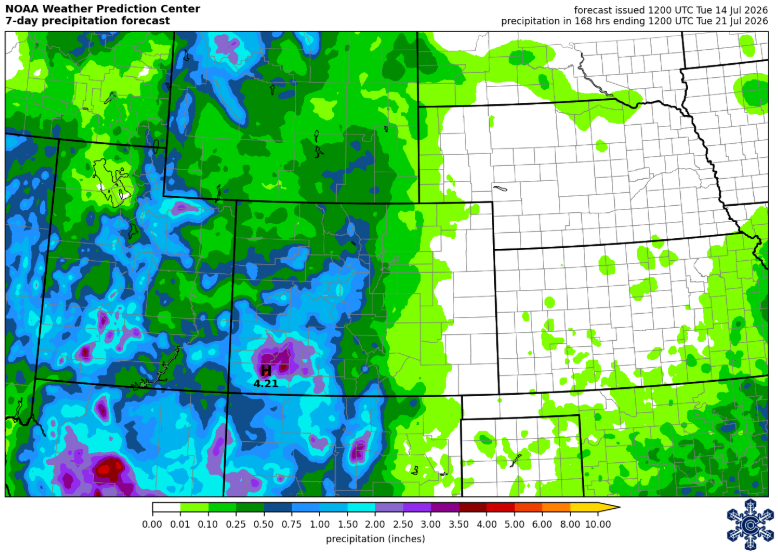
Figure 18: 7 Day Precipitation Forecast
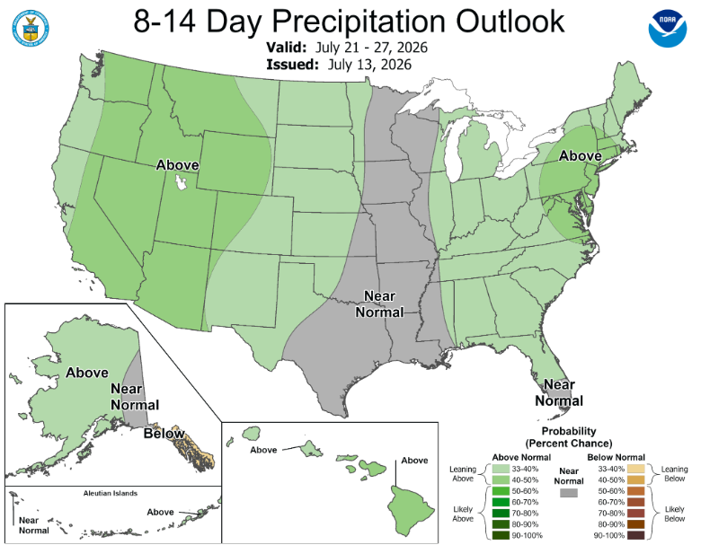
Figure 19: 8-14 Day Precipitation Outlook
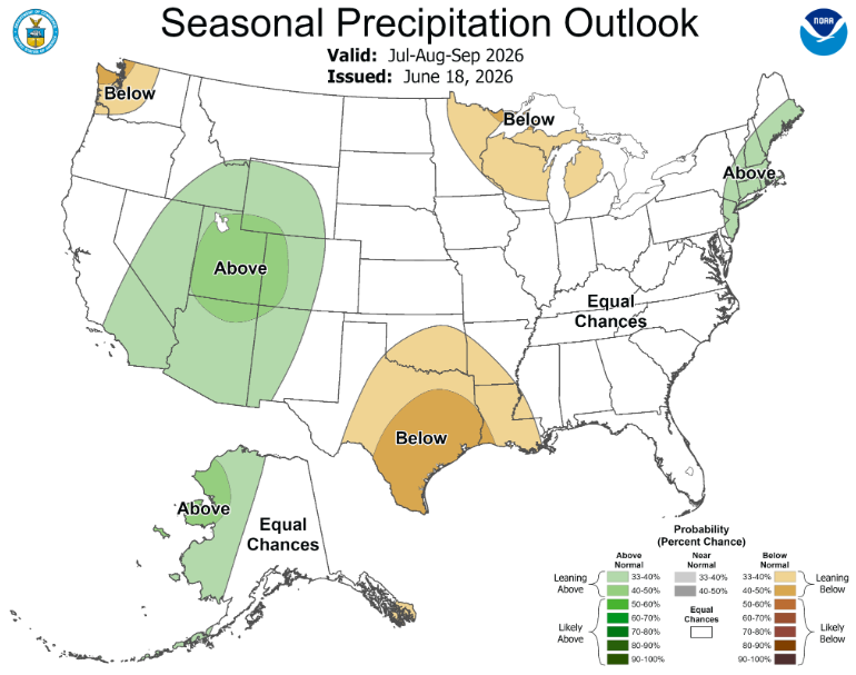
Figure 20: Seasonal Precipitation Outlook
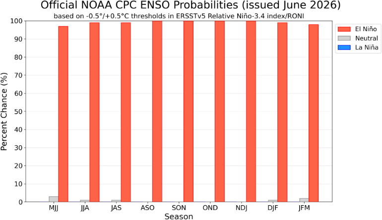
Figure 21: ENSO Probabilities
Temperature
Short term and long term forecasting models are showing above average temperatures in Colorado (figures 22 & 23).
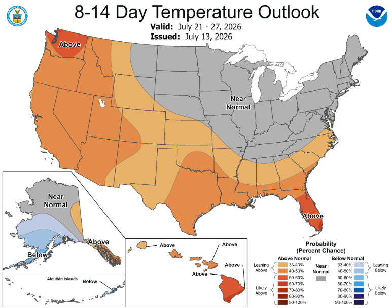
Figure 22: 8-14 Day Temperature Outlook
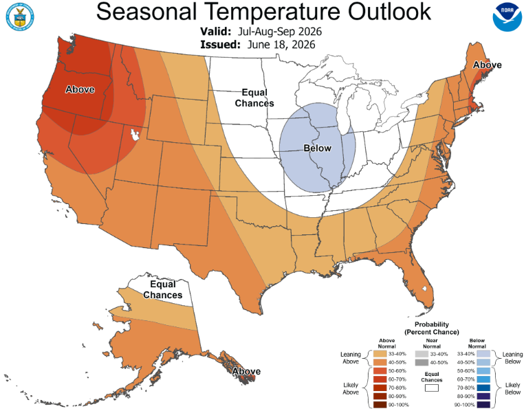
Figure 23: Seasonal Temperature Outlook
Wildfire Risk
USDA outlooks for wildfire potential continue to show above average risk in western Colorado in June and July (figure 24). The two largest fires currently affecting the Arkansas River Basin are Aspen Acres Fire and Willow Fire. Currently, Willow Fire is 7,196 acres at 51% containment. Aspen Acres Fire is at 101,545.4 acres at 61% containment.
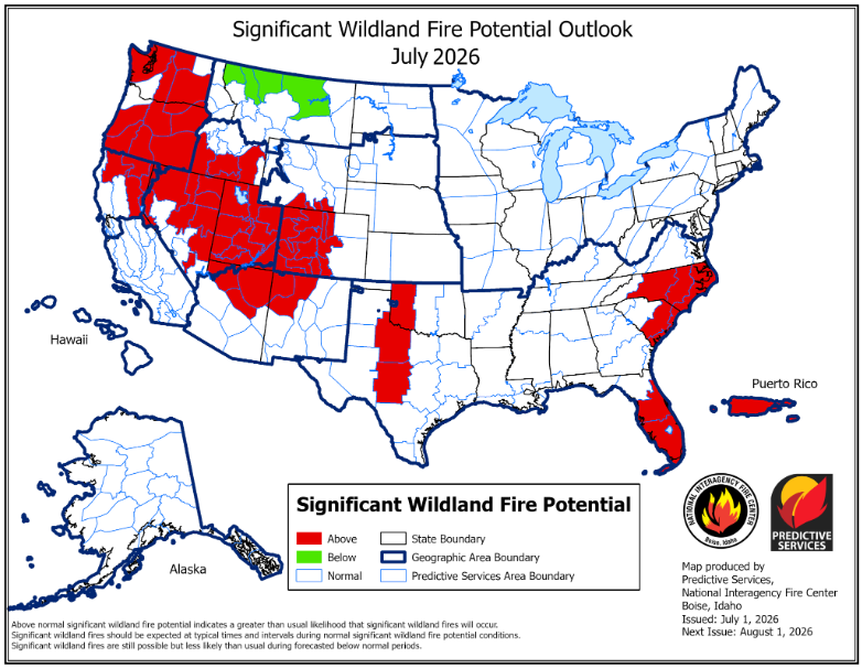
Figure 24: Significant Wildland Fire Potential Outlook
Drought Outlook
NOAA’s drought outlook suggests that conditions will improve across most of Colorado by the end of summer due to an expected active monsoon season (figure 25).
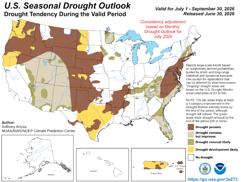
Figure 25: U.S. Seasonal Drought Outlook
Want to Learn More? Check out these resources below!
Monitoring
Drought Monitoring: US Drought Monitor
Drought Forecast: National Weather Service Climate Prediction Center
Precipitation Totals: Community Collaborative Rain, Snow, and Hail Network’s Precipitation Mapping System.
Snowpack: Natural Resources Conservation Service
Winter Water Storage System (only applicable until March): Southeastern Colorado Water Conservancy District
Precipitation: https://www.cocorahs.org/
Arkansas River Daily Report – http://www.div2waterops.com/dailyreports
Arkansas Streamflow: http://www.div2waterops.com/ColorsOfWater
Snow Survey and Water Supply Forecasting: Natural Resource Conservation Service Snow Survey
Additional monitoring resources:
Colorado Water Conservation District/Department of Natural Resources
Definitions
30 Year Running Average: When we present the monthly flows, we compare them to that month’s median flows from the last 30 years (referred to as 30 year running average).
Reservoir Percent Full: The Bureau of Reclamation considers a reservoir “full” when pool elevation is at the top of the active conservation pool. Percentage is therefore based on total reservoir volume below that level.
Educational Resources
Administrative Call Explained: DWR
Citizen’s Guide to Colorado Water Law: CFWE Education
Non-Attorney’s Guidebook to Colorado Water Courts: Co State
Voluntary Flow Management
- https://arkvalleyvoice.com/ahra-says-arkansas-river-flows-are-high-and-fast-making-safety-paramount/
- https://coloradotu.org/arkansas-river
U.S. Climate Normals: https://www.ncei.noaa.gov/products/land-based-station/us-climate-normals