
Temperature Trends
June 2025 in Colorado saw a mix of cool, wet periods and stretches of warm, dry weather. While statewide temperatures trended above average overall—making this the 23rd warmest June on record—conditions varied significantly across regions.
The western half of the state saw the most notable heat, with many areas recording a top-10 warmest June, particularly in northwest Colorado. Meanwhile, temperatures in southeast Colorado were closer to seasonal norms, with the Arkansas Basin experiencing more balanced swings between warm and cool periods.

Figure 1: June 2025 Average Monthly Temperatures Compared to Normal
figure 2: Colorado’s Monthly Temp Ranking
Drought & Precipitation
June was slightly wetter than normal statewide, with localized surpluses from active storm tracks in parts of northeast and southwest Colorado. On average, statewide precipitation totaled 1.54 inches, 0.09 inches above the long-term average.
Drought conditions improved across southern and eastern Colorado, thanks to June’s storms. However, northwest Colorado saw worsening dryness due to limited rainfall and persistent evaporative demand. These trends are reflected in streamflow shortfalls and soil moisture deficits, especially across the Western Slope.

figure 3: Colorado May 1st Drought Monitor
figure 4: Colorado monthly precip ranking
June Precipitation Totals
Leadville-0.59 in
Buena Vista-0.78 in
Salida-0.82 in
Cañon City-1.38 in
Pueblo -1.61 in
Rocky Ford-0.64 in
Lamar-2.21 in
Streamflow
June is typically when the Arkansas River in Colorado experiences peak streamflows due to snowmelt. Streamflow data from early June shows flows of 2080 cfs on June 9th and 1690 cfs on June 13th near Wellsville, according to Colorado Parks and Wildlife. Since then, flows have steadily dropped.

figure 7: Map of 28-day average streamflow compared to historical median
June Streamflow Summary
* measured flow totals include native flows, BOR project water, releases, and exchanges

figure 8: Map of river gauges in the Arkansas River Basin
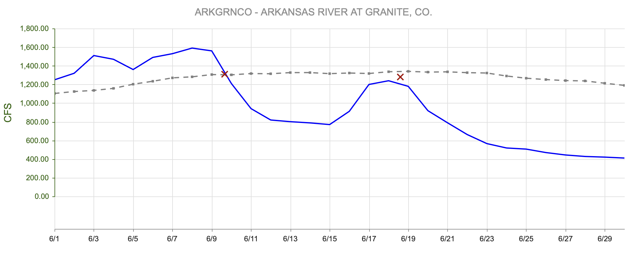
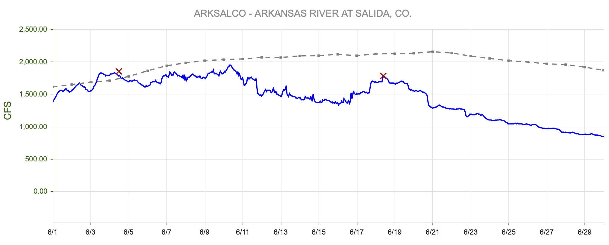
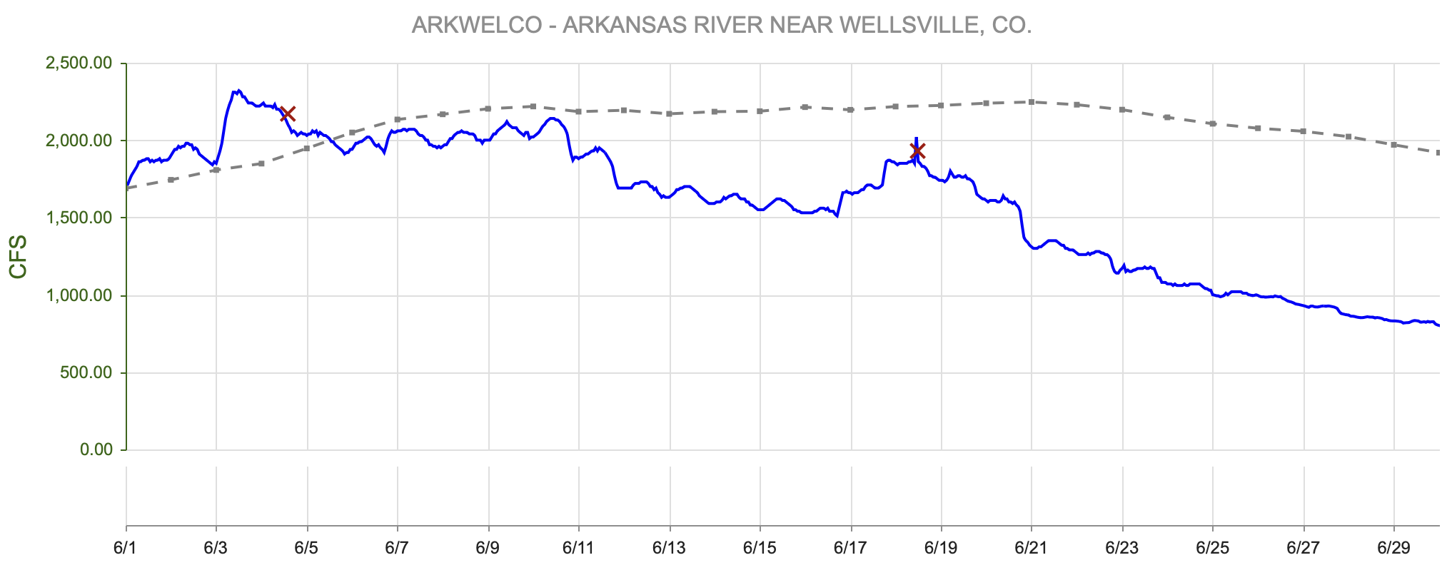
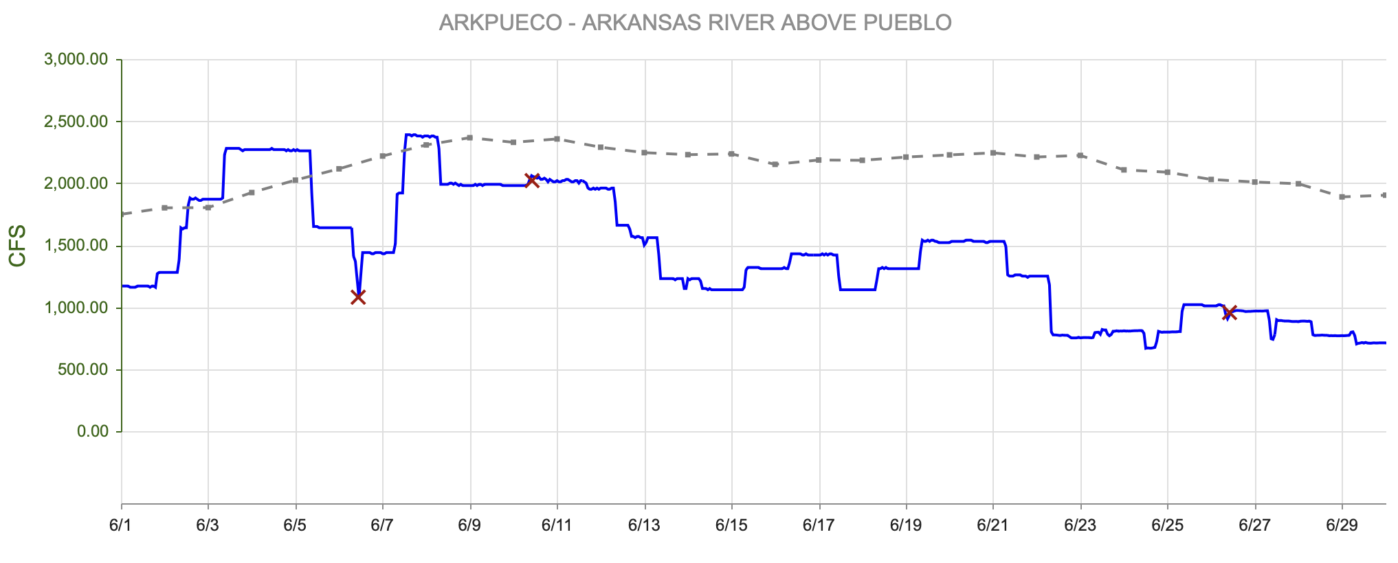
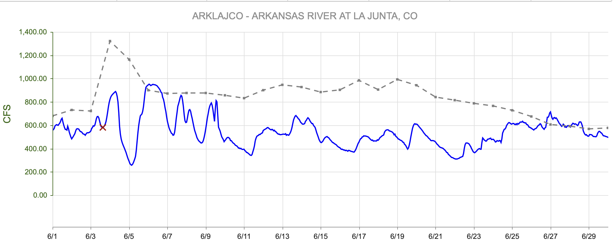
figure 9: Arkansas River Flows Upstream to Downstream Viewer
- Granite, CO (8 miles south of Leadville)- 175 cfs
- Salida, CO- 300 cfs
- Wellsville, CO- 305 cfs
- Portland, CO (10 miles south of Canon City)- 252 cfs
- Above Pueblo Reservoir, CO- 152 cfs
- Avondale, CO- 352 cfs
- Lamar, CO- 22.2 cfs
For current streamflow updates, reference the Colors of Water webpage.
Reservoir Storage

figure 10: Reservoir Storage Percent of Median

figure 11: 2025 Reservoir Percent of Capacity Compared to 2024

figure 12: Colorado Reservoir Storage Summary
Summer Outlook
As we head into summer, near-neutral ENSO conditions are now in place, bringing some uncertainty to the summer forecast. However, outlooks continue to favor above-average temperatures—especially in northern and eastern Colorado—and a lean toward drier-than-normal conditions across the state.
June brought some drought relief to the southern and eastern regions, but surface water supply concerns remain high across western Colorado. Without enhanced monsoon activity, water quantity stressors and wildfire risk may increase this summer.

figure 13: Three Month Temperature Outlook

figure 14: Three Month Precipitation Outlook
Want to Learn More? Check out these resources below!
Monitoring
Drought Monitoring: US Drought Monitor
Drought Forecast: National Weather Service Climate Prediction Center
Precipitation Totals: Community Collaborative Ran, Snow, and Hail Network’s Precipitation Mapping System.
Snowpack: Natural Resources Conservation Service
Winter Water Storage System (only applicable until march): Southeastern Colorado Water Conservancy District
Precipitation: https://www.cocorahs.org/
Arkansas River Daily Report – http://www.div2waterops.com/dailyreports
Wind: Windy
Snow Survey and Water Supply Forecasting: Natural Resource Conservation Service Snow Survey
Additional monitoring resources:
Colorado Water Conservation District/Department of Natural Resources
Definitions
30 Year Running Average: When we present the monthly flows, we compare them to that month’s median flows from the last 30 years (referred to as 30 year running average).
Reservoir Percent Full: The Bureau of Reclamation considers a reservoir “full” when pool elevation is at the top of the active conservation pool. Percentage is therefore based on total reservoir volume below that level.
Authorized Diversion: An authorized diversion is NOT A CALL, but a notice that one (or more) diversion structures are subject to a call have been authorized to divert water against the call. These types of diversions are only authorized when the diversion will not affect the downstream call. This type of diversion could occur due to a localized event, such as precipitation diurnal patterns (labeled futile diversion or localized event)
Nonconsumptive call: A call by a diversion that consumes no water (ex. Hydropower, in-stream flow water management).
Futile Call: A situation in which a junior water right holder is allowed to continue to divert in spite of a downstream senior call when curtailing the junior would not produce any additional water for the senior.
For more information on calls, reference the Colorado Division of Natural Resources Administrative Call Standard document.
Educational Resources
Administrative Call Explained: DWR
Citizen’s Guide to Colorado Water Law: CFWE Education
Non-Attorney’s Guidebook to Colorado Water Courts: Co State
Voluntary Flow Management
- https://arkvalleyvoice.com/ahra-says-arkansas-river-flows-are-high-and-fast-making-safety-paramount/
- https://coloradotu.org/arkansas-river
U.S. Climate Normals: https://www.ncei.noaa.gov/products/land-based-station/us-climate-normals