Project Background
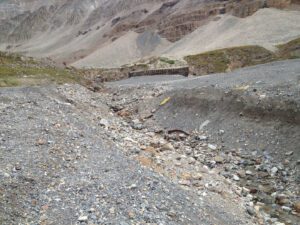
The Sherman Mine, also known as Day Mines, is situated in the upper Iowa Gulch at the base of Mt. Sherman, approximately 8 miles northwest of Leadville. The mine operated from 1968 to 1982, primarily producing silver, lead, and zinc. In 2008, the Colorado Division of Reclamation, Mining, and Safety (DRMS) completed reclamation efforts to reestablish the natural drainage route through Iowa Gulch and stabilize the waste rock pile. However, lateral erosion from runoff and storm events has since destabilized and widened the channel, causing the transport of waste rock and degradation of sensitive wetland areas downstream. This project aims to construct grouted riprap channels to stabilize the waste rock and prevent further sedimentation, thereby protecting the wetland ecosystem below the mine.
Approach
The project will address approximately 2,000 feet of drainage channel, divided into the North Channel, South Channel, and Energy Dissipation zones. The channels will be stabilized using a combination of grouted riprap and boulders, providing a long-term solution to the excessive erosion and material mobilization that threaten the wetland. This stabilization effort is particularly critical given a 2008 blowout at the mine portal, which sent 8,000 to 10,000 cubic yards of material downstream. The project will be conducted entirely on Bureau of Land Management (BLM) lands, with the added benefit of restoring approximately 2 acres of wetland habitat. The improved habitat will support native greenback trout and enhance recreational fishing opportunities on public lands.
Expected Outcome
The Sherman Mine Channel Construction Project aims to significantly reduce sediment loads entering the downstream wetland, leading to improved habitat for native fish species such as the greenback trout. In addition to habitat restoration, the project will enhance public access to recreational fishing opportunities on BLM lands, contributing to both environmental and community benefits.

Trout Unlimited ‘s Sherman Mine Restoration Site
