Arkansas River Report for September 2024
Drought and Precipitation
As September ends, so to does the 2024 water year. According to the U.S.Geological Survey , a “water year” is defined as the 12-month period October 1, for any given year through September 30, of the following year. The water year is designated by the calendar year in which it ends and which includes 9 of the 12 months. Thus, the year ending September 30, 1999 is called the “1999” water year.
The CWCB September Water Conditions Committee reports that precipitation for this water year is slightly above the median for the last 30 years. Higher totals in the state are above 42 inches, which has contributed to increased runoff and reservoir storage.
According to the most recent U.S, Drought Monitor, most of the Arkansas River Basin is abnormally dry or drought free, with moderate or severe drought only along the Kansas-Colorado (figure 1). In general, recent drought reports indicate that western Colorado has seen less severe drought conditions, and eastern Colorado has seen more server drought.

figure 1: US Drought Monitor (9/26/2024)
The National Weather Service’s Three Month Outlook is predicting that there will likely be above-normal temperatures and leaning towards a warmer/drier conditions in the Arkansas River basin through December (figure 3; figure 4). These models are based on a predicted shift to La Niña. During La Niña cycles, Colorado typically sees dry falls and snowy winters. As of now, the Colorado Climate Center reports an 80% chance that La Niña will develop by the winter.


figure 3: Three month temperature outlook
figure 4: Three month precipitation outlook
September Precipitation Totals
The Arkansas River Basin saw some early season snow this month! The NRCS Snow Survey reports that 1″-3″ of snow fell at higher elevations.
In the Arkansas River basin, the Community Collaborative Rain, Snow and Hail Network reports the following total precipitation amounts, in inches for the month of September in the Arkansas Basin (ranges indicate variability across stations):
Leadville – 1.01″
Buena Vista -1.16″
Salida – 0.58”
Cañon City – 1.29-1.71”
Walsenburg – 2.42”
Trinidad – 1.23”
Pueblo – 0.68”
Westcliffe – 1.42-1.79”
Colorado Springs – 0.87″
Rocky Ford – 0.36”
Lamar-0.79-1.44”
River Flows
September Flows Compared to Median
*30 year running avg


River Flow Snapshot (9/30/2024,12:00pm)*
* measured flow totals include native flows, BOR project water, releases, and exchanges
- Granite, CO (8 miles south of Leadville)- 296 cfs
- Salida, CO- 406 cfs
- Wellsville, CO- 413 cfs
- Portland, CO (10 miles south of Canon City)- 400 cfs
- Above Pueblo Reservoir, CO- 610 cfs
- Avondale, CO- 528 cfs
- Lamar, CO- 13.8 cfs
For current streamflow updates, reference the Colors of Water webpage.
Reservoir Storage
|
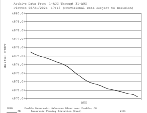
figure 5: Pueblo Reservoir September elevation
|
figure 6: Pueblo Reservoir Storage Allocations
|

|
figure 7: Twin Lakes Reservoir September Elevation
|
figure 8: Twin Lakes Reservoir Allocations
|


|
figure 9: Turquoise Lake September elevation
|
figure 10: Turquoise Lake Storage Allocations
|

Reservoir Storage Snapshot (9/30/2024, 12:00pm)
- Pueblo Reservoir-
- Pool Elevation: 4868.38 Feet
- Reservoir Storage: 196344 Acre-Feet
- 60.8 % Full*
- Reservoir Flood Control Pool: filled 0.0 %
- Turquoise Lake-
- Pool Elevation: 9862.5 Feet
- Reservoir Storage: 117204 Acre-Feet
- 90.6 % Full*
- Reservoir Flood Control Pool: filled 0.0 %
- Twin Lakes Reservoir-
- Pool Elevation: 9191.3 Feet
- Reservoir Storage: 118467 Acre-Feet
- 84 % Full*
- Reservoir Flood Control Pool: filled 0.0 %
Calling Water Rights
Active Administrative Calls Snapshot (9/3/2024, 12:00pm)
The current calling rights are:
1862, Canon Heights Ditch, Fourmile Creek.
1865, Burroughs Ditch, Hardscrabble Creek.
1865, Hoehne Ditch, Purgatoire River.
1866, Walsenburg Ditch, Cucharas River.
1866, Gonzales Ditch, Apishapa River.
1868, Hayden Supply Ditch, Greenhorn Creek.
1873, Stout Ditch No. 3, Stout Creek.
1873, Whitman and Mott Ditch, Apache Creek.
1881, Dotson Ditch No. 1, Saint Charles River.
1883,Cameron Ditch, North Fork South Arkansas River.
1882, Tennessee Ditch, South Arkansas River.
1884, Catlin Canal, Arkansas River Mainstem.
1885, Wolf and Neerland Ditch, Cottonwood Creek.
1886, Buffalo Canal, Arkansas River Mainstem.
1949, Arkansas River Compact, Arkansas River mainstem.
The authorized diversions are:
1889, Welton Ditch, Huerfano River.
1891, Sunnyside Park Ditch, Arkansas River mainstem.
1904, Dell Ditch No. 1, Currant Creek.
1907, Joseph Dunn Ditch, Lake Fork.
1911, Plum Creek Ditch, Plum Creek.
1912, New Salida Ditch, Arkansas River mainstem.
1912, Rock Creek Ditch, Rock Creek.
1912, Lake Creek Ditch, Lake Fork.
The Futile Call is:
1948, Almstrum Ditch, Thirtyone Mile Creek.
Bob Hamel Q&A
For this river report, I (Cecilia, ARWC’s Watershed Resources Intern) spoke with Bob Hamel. Bob Hamel is the executive director of the Arkansas River Outfitters Association and serves as vice chair (nonconsumptive) of the Arkansas Basin Roundtable and chairman of the environment/recreation committee.

1. What is your role with the roundtable and how did you end up in that position?
I represent recreation. I’m in the at-large recreation representative position and with that I because we have like kind of like two branches right we We have Jeff DeHerrera, who’s the vice chair of that arm, and I vice chair the roundtable for the non-consumptive users, of which there’s just us and the environmental folks. So, much smaller on my little team.
2. How long have you been in that position?
Seven or eight years.
3. What does that position entail?
With that position, I also chair the Environmental Recreation Committee. We meet every other month or so and then report back to the roundtable to bring the voice of recreation. My main job is executive director with the Arkansas River Outfitters Association, and because I work with them, the round table fell into my lap, basically. It’s something that I can participate in and represent recreation, the boating community. Because I work with the outfitters and our interest in the roundtable is to making sure we have water and we work on building partnerships with the water community to help support the Voluntary Flow Management Plan, an augmentation plan that gives us potential to have water added to the river from July 1st to August 15th to get us to 700 CFS. In the years that I’ve been doing the roundtable, we’ve built these partnerships which are really solid now with people like from Pueblo, Board of Water Works, Allen Ward, they really understand what we need and how they can help us.
They’ve helped us move water to supplement the water that’s in the VFMP through the Bureau of Reclamations program. Water is complicated here.
4. During your time doing this work, how have you seen the conversation around water management in the basin evolve?
Oh, it has changed big time. There’s a lot of transparency now, and the acknowledgement of the importance of water quality and watershed health. That is in part due to you all (ARWC), and the well supported projects that you have facilitated. It’s pretty cool to watch the whole conversation, and resulting actions, develop.
It has also changed because people managing water in the valley acknowledge the recreation communities existence and are willing to help us, as opposed to just doing what they need to do whenever they need to do it without referring to us. It benefits the whole boating community when they are willing to make movements of water at times that are beneficial to us
In the last two years prior to this year, Pueblo has moved ~6,000 acre feet of water each year during the flow program time frame to help us extend the amount of water we had available to maintain that 700 CFS. They did not have to do it. They could have moved it before or waited until after or moved it in the winter or whatever, but they’re like, hey, we got this water to move one will be a good time to move it. Well As we expressed, you know what our time frame is and July 1st, August 15th, they had it they were willing to do it. It’s been incredible, actually, in the last eight years.
5. Now that the Voluntary Flow Management Program has come to a close, what are you thinking about come fall and winter?
I chair the committee of the Arkansas River Basin Water Forum. We have begun planning for our annual event.. We do a four-city rotation. In March 2025, March, we’ll be in Pueblo. And then we go to Salida, and then Colorado Springs, and back to La Junta. Each session is a little more focused on what’s going on around those towns. We focus on municipality needs when we’re in Colorado Springs. In Pueblo and La Junta, we talk a lot about agriculture and then a little more with recreation and ranching when we’re in the upper basin in Salida. So it’s an opportunity for us to be one-on-one with people for a couple days to be able to talk about what local needs are.
Things have evolved in these last eight years with the water community and just understanding what each other is doing helps us balance between agriculture, recreational, environmental and municipality needs.
Want to Learn More? Check out these resources below!
Monitoring
Drought Monitoring: US Drought Monitor
Drought Forecast: National Weather Service Climate Prediction Center
Precipitation Totals: Community Collaborative Ran, Snow, and Hail Network’s Precipitation Mapping System.
Snowpack: Natural Resources Conservation Service
Winter Water Storage System (only applicable until march): Southeastern Colorado Water Conservancy District
Precipitation: https://www.cocorahs.org/
Arkansas River Daily Report – http://www.div2waterops.com/dailyreports
Wind: Windy
Snow Survey and Water Supply Forecasting: Natural Resource Conservation Service Snow Survey
Additional monitoring resources:
Colorado Water Conservation District/Department of Natural Resources
Definitions
30 Year Running Average: When we present the monthly flows, we compare them to that month’s median flows from the last 30 years (referred to as 30 year running average).
Reservoir Percent Full: The Bureau of Reclamation considers a reservoir “full” when pool elevation is at the top of the active conservation pool. Percentage is therefore based on total reservoir volume below that level.
Authorized Diversion: An authorized diversion is NOT A CALL, but a notice that one (or more) diversion structures are subject to a call have been authorized to divert water against the call. These types of diversions are only authorized when the diversion will not affect the downstream call. This type of diversion could occur due to a localized event, such as precipitation diurnal patterns (labeled futile diversion or localized event)
Nonconsumptive call: A call by a diversion that consumes no water (ex. Hydropower, in-stream flow water management).
Futile Call: A situation in which a junior water right holder is allowed to continue to divert in spite of a downstream senior call when curtailing the junior would not produce any additional water for the senior.
For more information on calls, reference the Colorado Division of Natural Resources Administrative Call Standard document.
Educational Resources
Administrative Call Explained: DWR
Citizen’s Guide to Colorado Water Law: CFWE Education
Non-Attorney’s Guidebook to Colorado Water Courts: Co State
Voluntary Flow Management
- https://arkvalleyvoice.com/ahra-says-arkansas-river-flows-are-high-and-fast-making-safety-paramount/
- https://coloradotu.org/arkansas-river
U.S. Climate Normals: https://www.ncei.noaa.gov/products/land-based-station/us-climate-normals