Temperature Trends
March 2025 in the Arkansas River Basin saw a mix of weather patterns, with temperatures fluctuating throughout the month. While early March brought mild spring-like conditions, temperatures took a dip later on in the month.
For much of the month, the region experienced temperatures typical of early spring, with daytime highs in the 40s and 50s °F and nighttime lows ranging from the 20s to low 30s °F, a typical March in the Arkansas River Basin (figure 1). However, a cold front moved through mid-month, bringing a brief but sharp drop in temperatures. During this period, daytime highs barely reached the 40s, and overnight lows dropped back into the teens and 20s °F across the basin.
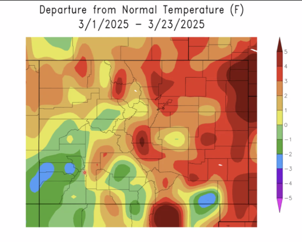
figure 1: Colorado’s March temperatures’ departure from normal (30-year running avg.)
Where does this leave us for our current water year? Colorado is currently tied for the 21st hottest first 5 month in the past 130 years (figure 2).
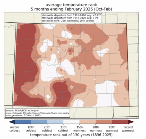
figure 2: Colorado’s Water Year to Date Temp Ranking
Drought & Snowfall
According to the most recent U.S, Drought Monitor, all of the Arkansas River Basin is now abnormally dry or in a moderate drought (figure 3). This is a significant shift from earlier years, when most of the basin was either classified as abnormally dry or drought free.
Despite that, much of the Arkansas has had a wetter than average overall water year (figure 4). This is owed substantially to the November snowstorm that hit Southeastern Colorado. Since that snowstorm, Southeastern Colorado has not had a significant amount of precipitation (figure 5). This means that while the top layer of soil may be dry, there is still a fair amount of moisture in the ground in this region.

figure 3: US Drought Monitor
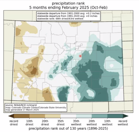
figure 4: Colorado’s Water Year to Date Precipitation Ranking
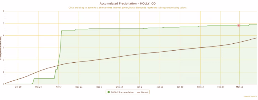
figure 5: precipitation accumulation in Holly, CO
As of March 2025, the Arkansas River Basin in Colorado continues to experience below-average snowpack levels. Recent data indicates that the snow water equivalent (SWE) stands at 79% of the median, reflecting a persistent shortfall compared to historical averages (figure 6; 7; 8).
March has been a fairly good snow month, but not enough to make up for the deficit from earlier in the snow season. The Arkansas River Valley has been particularly dry, with some pockets of above average precipitation where we got some snow in the past few weeks.
This trend aligns with broader patterns observed across southern Colorado, where regions such as the San Miguel-Dolores-Animas-San Juan and Upper Rio Grande basins are similarly underperforming in snow accumulation. These deficits are attributed to a combination of reduced snowfall and warmer temperatures, which have led to increased evaporation and earlier-than-expected snowmelt.
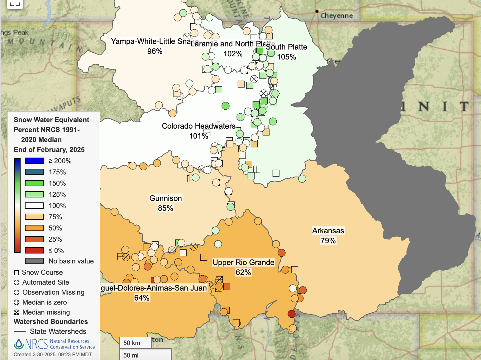
figure 6: Colorado’s Water Year-to-Date Precipitation Percent of Median
The implications of these conditions are significant, as the Arkansas River Basin relies heavily on snowmelt to replenish water supplies for agricultural, municipal, and ecological needs. The reduced snowpack raises concerns about water availability in the coming months, potentially affecting crop irrigation, municipal water reserves, and river ecosystems.
April is typically the wettest month of the year for lower elevations in Northwestern Colorado & a significant month for precipitation across the state A handful of early April snowstorms are predicted, though the totals are not likely to restore snowpack levels to average in the Arkansas River Basin (figure 7)
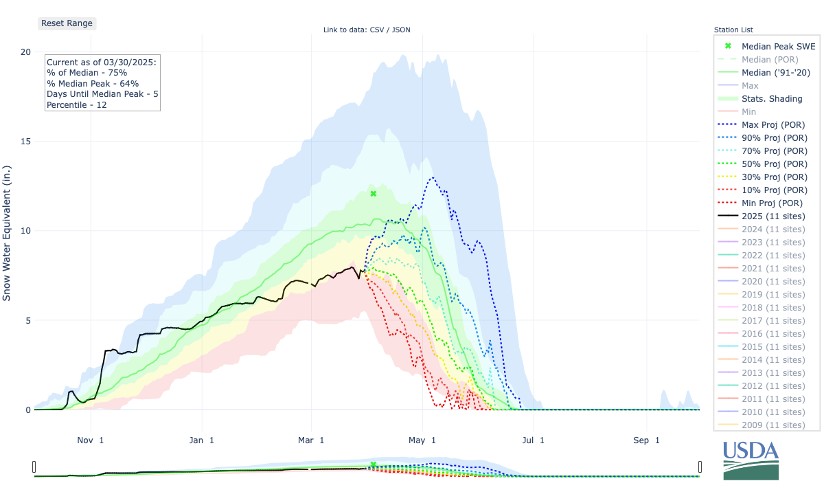
figure 7: Snow Water Equivalent Projection in the Arkansas River Basin
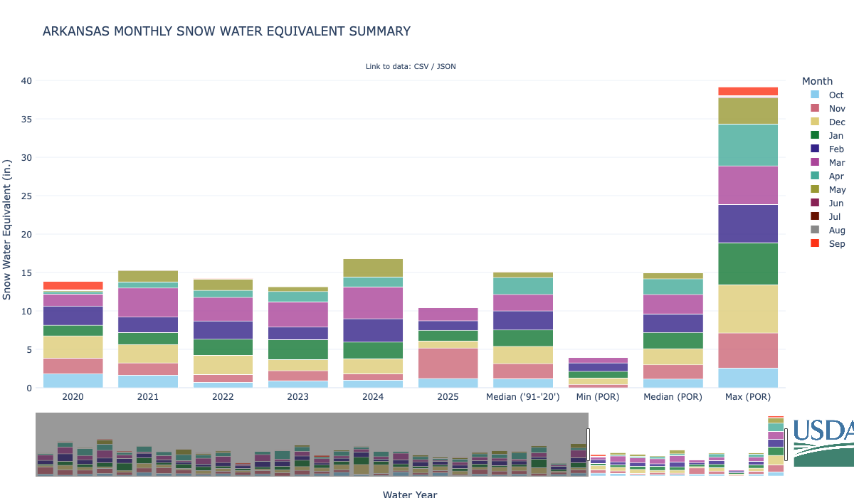
figure 8: Snow Water Equivalent in the Arkansas River Basin
Streamflow
As of March 2025, streamflow in the Arkansas River Basin is holding steady, staying pretty close to what we’d expect for this time of year (figure 9). Despite the snowpack being below average, the streamflows have been steady, thanks to some recent rain and the gradual melt of existing snow.
In February, a big snowstorm up north added some moisture, which will help with streamflows in the coming months. However, the southern parts of the basin, including the Arkansas River Basin, didn’t see as much snow, so there are still some concerns about water availability as we head into spring and summer.
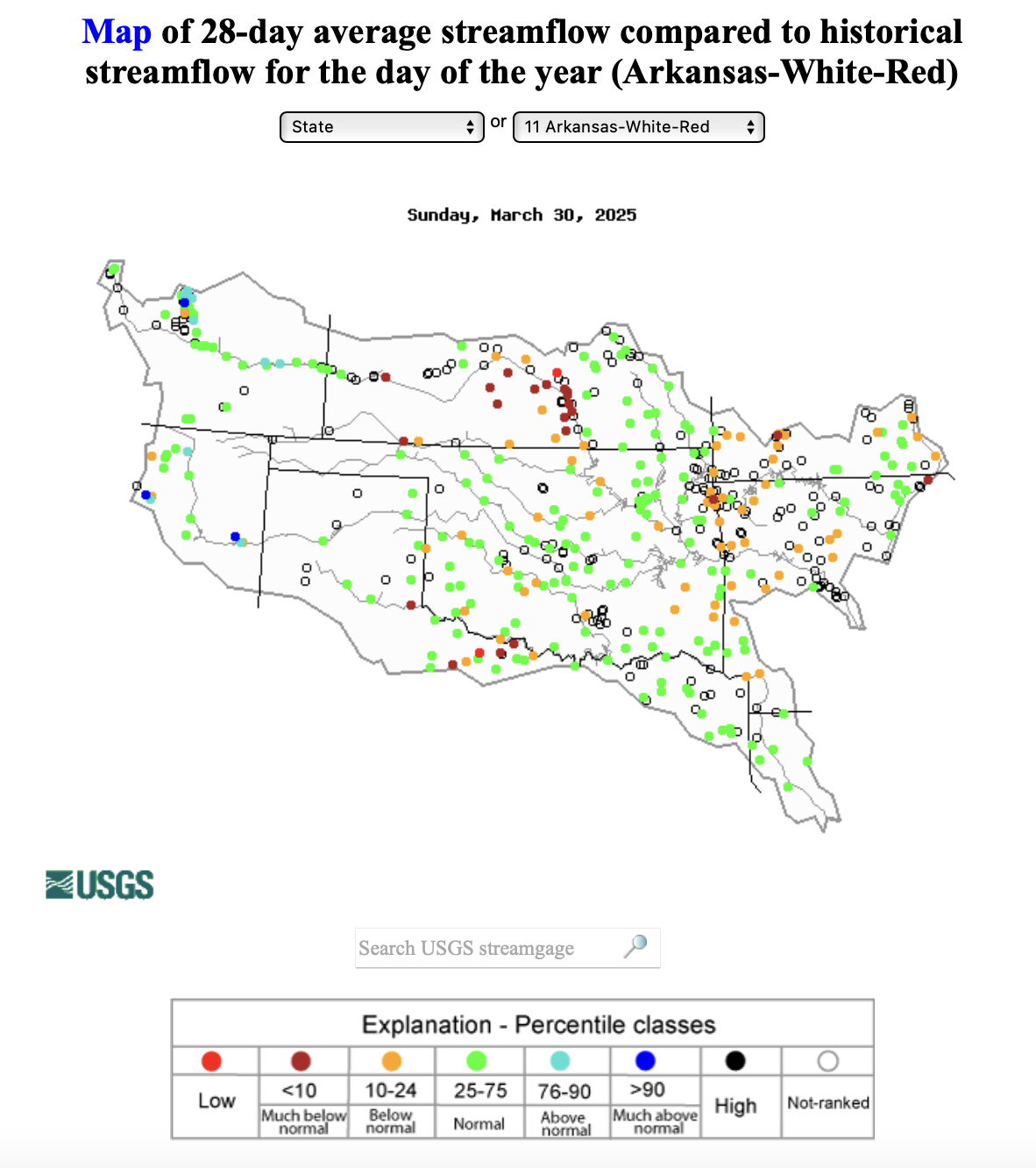
figure 9: Map of 28-day average streamflow compared to historical median
River Flow Snapshot (4/1/2025, 9:15am)*
* measured flow totals include native flows, BOR project water, releases, and exchanges

figure 10: Map of river gauges in the Arkansas River Basin
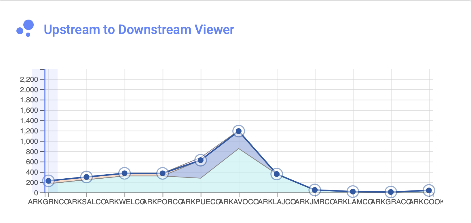
figure 11: Arkansas River Flows Upstream to Downstream Viewer
- Granite, CO (8 miles south of Leadville)- 226 cfs
- Salida, CO- 301 cfs
- Wellsville, CO- 372 cfs
- Portland, CO (10 miles south of Canon City)- 371 cfs
- Above Pueblo Reservoir, CO- 626 cfs
- Avondale, CO- 1190 cfs
- Lamar, CO- 358 cfs
For current streamflow updates, reference the Colors of Water webpage.
Reservoir Storage
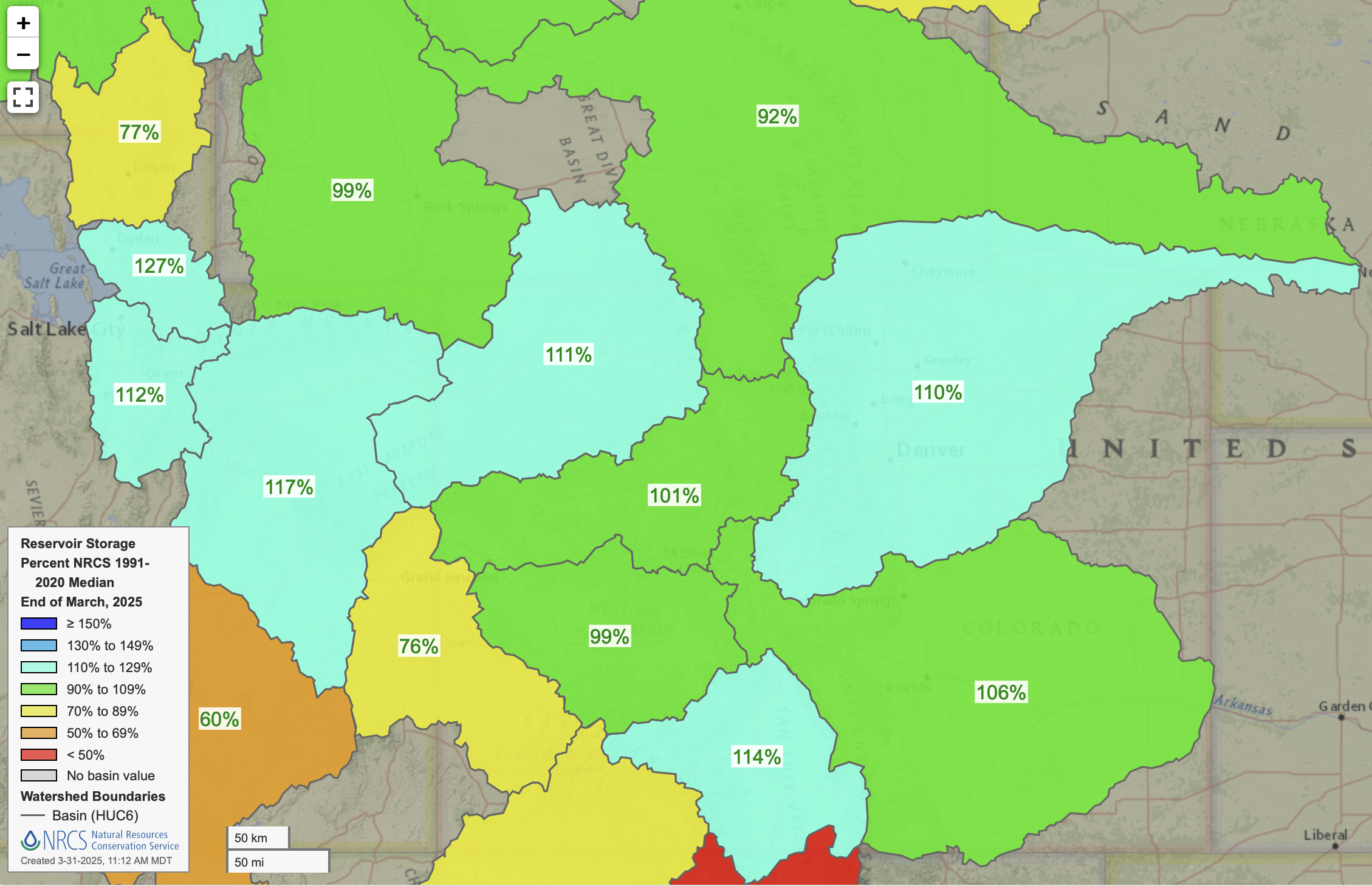
figure 12: Reservoir Storage Percent of Median
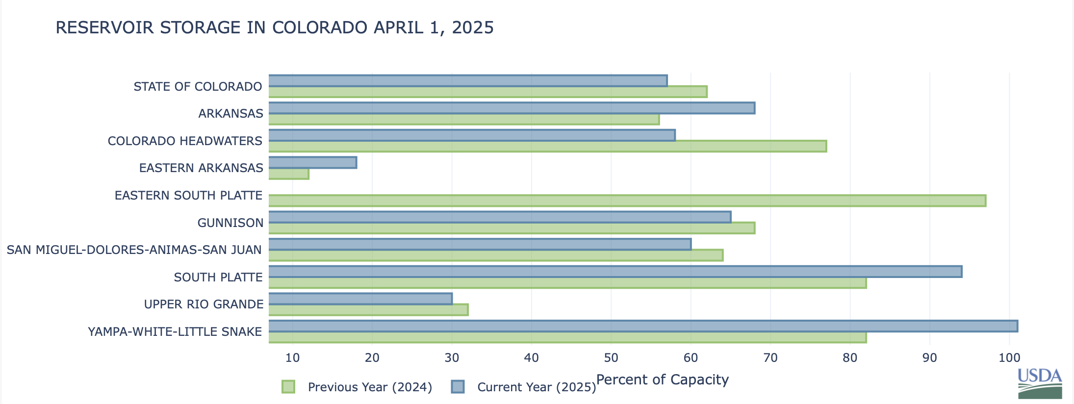
figure 13: Reservoir Storage on April 1st
Forecast & ENSO Conditions
La Niña conditions still are in place, but a transition to ENSO-neutral most likely during the Feb-April 2025 time period (75% chance) and is favored to persist through the Northern Hemisphere summer 2025. During October-December 2025, there are equal chances (42%) of ENSO-neutral and La Niña. If La Niña conditions remain in place, or its effects linger, La Niña typically brings above-average snow to the northern mountains and less to the south. With La Niña conditions waning, however, early outlooks are forecasting an active monsoon season.
The three month temperature and precipitation outlooks overall are predicting above average temperatures and below average precipitation for the region (figure 15; 16).
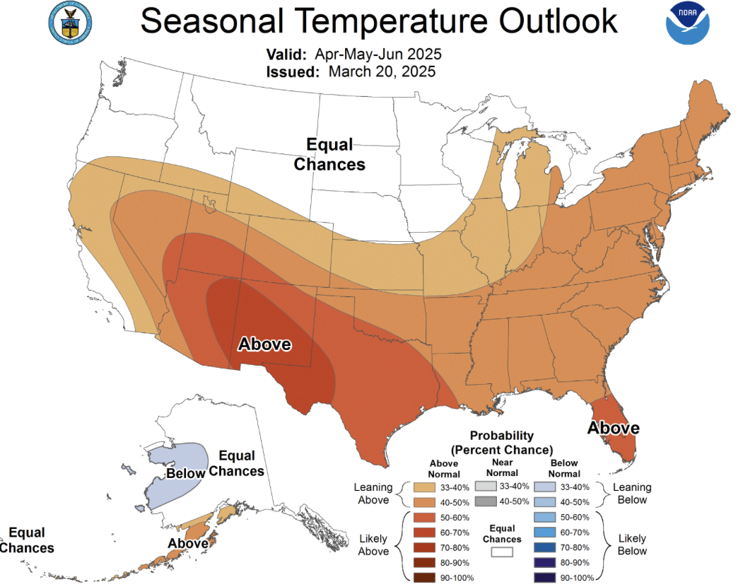
figure 15: Three Month Temperature Outlook
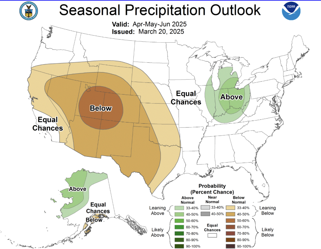
figure 16: Three Month Precipitation Outlook
Want to Learn More? Check out these resources below!
Monitoring
Drought Monitoring: US Drought Monitor
Drought Forecast: National Weather Service Climate Prediction Center
Precipitation Totals: Community Collaborative Ran, Snow, and Hail Network’s Precipitation Mapping System.
Snowpack: Natural Resources Conservation Service
Winter Water Storage System (only applicable until march): Southeastern Colorado Water Conservancy District
Precipitation: https://www.cocorahs.org/
Arkansas River Daily Report – http://www.div2waterops.com/dailyreports
Wind: Windy
Snow Survey and Water Supply Forecasting: Natural Resource Conservation Service Snow Survey
Additional monitoring resources:
Colorado Water Conservation District/Department of Natural Resources
Definitions
30 Year Running Average: When we present the monthly flows, we compare them to that month’s median flows from the last 30 years (referred to as 30 year running average).
Reservoir Percent Full: The Bureau of Reclamation considers a reservoir “full” when pool elevation is at the top of the active conservation pool. Percentage is therefore based on total reservoir volume below that level.
Authorized Diversion: An authorized diversion is NOT A CALL, but a notice that one (or more) diversion structures are subject to a call have been authorized to divert water against the call. These types of diversions are only authorized when the diversion will not affect the downstream call. This type of diversion could occur due to a localized event, such as precipitation diurnal patterns (labeled futile diversion or localized event)
Nonconsumptive call: A call by a diversion that consumes no water (ex. Hydropower, in-stream flow water management).
Futile Call: A situation in which a junior water right holder is allowed to continue to divert in spite of a downstream senior call when curtailing the junior would not produce any additional water for the senior.
For more information on calls, reference the Colorado Division of Natural Resources Administrative Call Standard document.
Educational Resources
Administrative Call Explained: DWR
Citizen’s Guide to Colorado Water Law: CFWE Education
Non-Attorney’s Guidebook to Colorado Water Courts: Co State
Voluntary Flow Management
- https://arkvalleyvoice.com/ahra-says-arkansas-river-flows-are-high-and-fast-making-safety-paramount/
- https://coloradotu.org/arkansas-river
U.S. Climate Normals: https://www.ncei.noaa.gov/products/land-based-station/us-climate-normals
