Arkansas River Report for February 2025
Temperature Trends
February 2025 in the Arkansas River Basin was a bit of a mixed bag when it came to temperatures. While the month was mostly in line with typical February conditions, there were some notable shifts, especially at the end. Overall, temperatures were close to the seasonal average, but a cold front late in the month brought a brief but sharp drop in temperatures, reminding everyone that winter was still in charge.
For much of the month, the Arkansas River Basin experienced typical February weather. Daytime highs were in the 40s and 50s °F, and nighttime lows dipped into the teens and 20s °F—pretty much what you’d expect for mid-winter in the region. However, a significant cold front moved through toward the end of the month, bringing temperatures down well below average. During this period, highs struggled to get above freezing, and in some areas, nighttime lows dropped into the single digits, a sharp contrast to the milder conditions earlier in the month.

figure 1: Colorado’s February temperatures’ departure from normal (30-year running avg.)
Across the state, the temperature trends were divided. East of the Continental Divide, Colorado saw cooler-than-average temperatures for most of February, in line with typical winter air patterns (figure 1). On the other hand, the western side of the divide experienced above-average temperatures, which made it feel a bit more like early spring. The Arkansas River Basin, located to the east, followed a similar pattern, with periods of warm weather giving way to the cold front that brought a dramatic chill at the end of the month.
In the early days of February, there was a short stretch of unseasonably warm weather, with temperatures reaching into the 50s °F—well above the usual February highs (figure 2). This warmth was a nice break from the cold but didn’t last long. By the end of the month, the cold front swept in, bringing much colder temperatures and a return to typical winter conditions (figure 3). This shift was particularly noticeable in the surrounding mountain areas, where snow accumulation was higher than usual due to the cold front’s arrival. Overall, while February 2025 was fairly typical temperature-wise, it was marked by significant temporal and spatial variability.

figure 2: February 3rd’s Daily Max Temps

figure 3: Feb 18th’s Daily Low Temps
Drought & Snowfall
According to the most recent U.S, Drought Monitor, all of the Arkansas River Basin is now abnormally dry or drought free (figure 4)! Looking back over the past 12 weeks, drought conditions in the Arkansas River Basin have remained mostly stable, with little change (figure 5).

figure 4: US Drought Monitor

figure 5: 12-Week Drought Class Change
February 2025 in the Arkansas River Basin experienced some notable shifts in snowpack conditions, but it was a bit of a mixed bag overall. The month started off with a bit of whiplash in terms of weather—largely feeling like spring, with unseasonably warm temperatures and conditions that were more reminiscent of early spring than mid-winter.
However, February did have a notable exception: the big Valentine’s Day snowstorm. This 4-day storm brought heavy snow, and many areas saw impressive accumulations. In the Arkansas River Basin, the snow water equivalent (SWE) finished the month at 77% of the median, which marks a decline from this time last month (figure 6). Despite the Presidents’ Day storm adding some moisture, the overall snowpack remains below average for this time of year.

figure 6: Colorado’s Water Year-to-Date Precipitation Percent of Median
As we move into the spring, we are possibly transitioning to neutral ENSO (El Niño-Southern Oscillation) conditions. This shift could make for an interesting end to the season, as it will likely influence precipitation patterns going into March and April (figure 7). We’re all waiting to see how the spring weather unfolds, especially since snowpack and water supply in the Arkansas River Basin rely heavily on the conditions that these last couple of months bring. With the snowpack currently at 77% of median SWE, the region still has some room for improvement

figure 7: Snow Water Equivalent Projection in the Arkansas River Basin

figure 8: Snow Water Equivalent This February Compared to Last February

Streamflow
In February 2025, streamflow in the Arkansas River Basin has generally followed expected patterns, with flows staying close to historical averages for this time of year (figure 10). While streamflow was steady across much of the basin, some local tributaries experienced slight fluctuations, which can be attributed to recent temperature swings and the amount of precipitation received during the month.
When comparing to historical medians, streamflow in February 2025 was largely in line with expectations for late winter, though some areas may have seen slightly lower flows due to the below-average snowpack heading into the season (figure 11). With snow water equivalent (SWE) at 77% of the median by the end of February, streamflow trends are expected to slightly lag behind typical spring runoff levels unless more significant snowstorms occur in the coming weeks.

figure 10: Map of 28-day average streamflow compared to historical median
When comparing to historical medians, streamflow in February 2025 was largely in line with expectations for late winter, though some areas may have seen slightly lower flows due to the below-average snowpack heading into the season (figure 11). With snow water equivalent (SWE) at 77% of the median by the end of February, streamflow trends are expected to slightly lag behind typical spring runoff levels unless more significant snowstorms occur in the coming weeks.
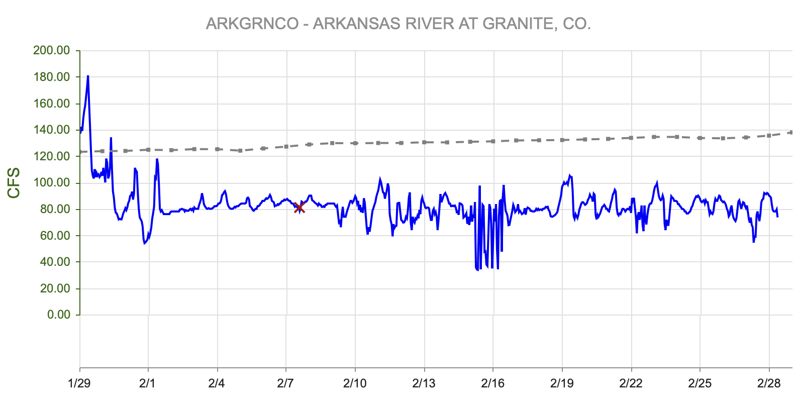
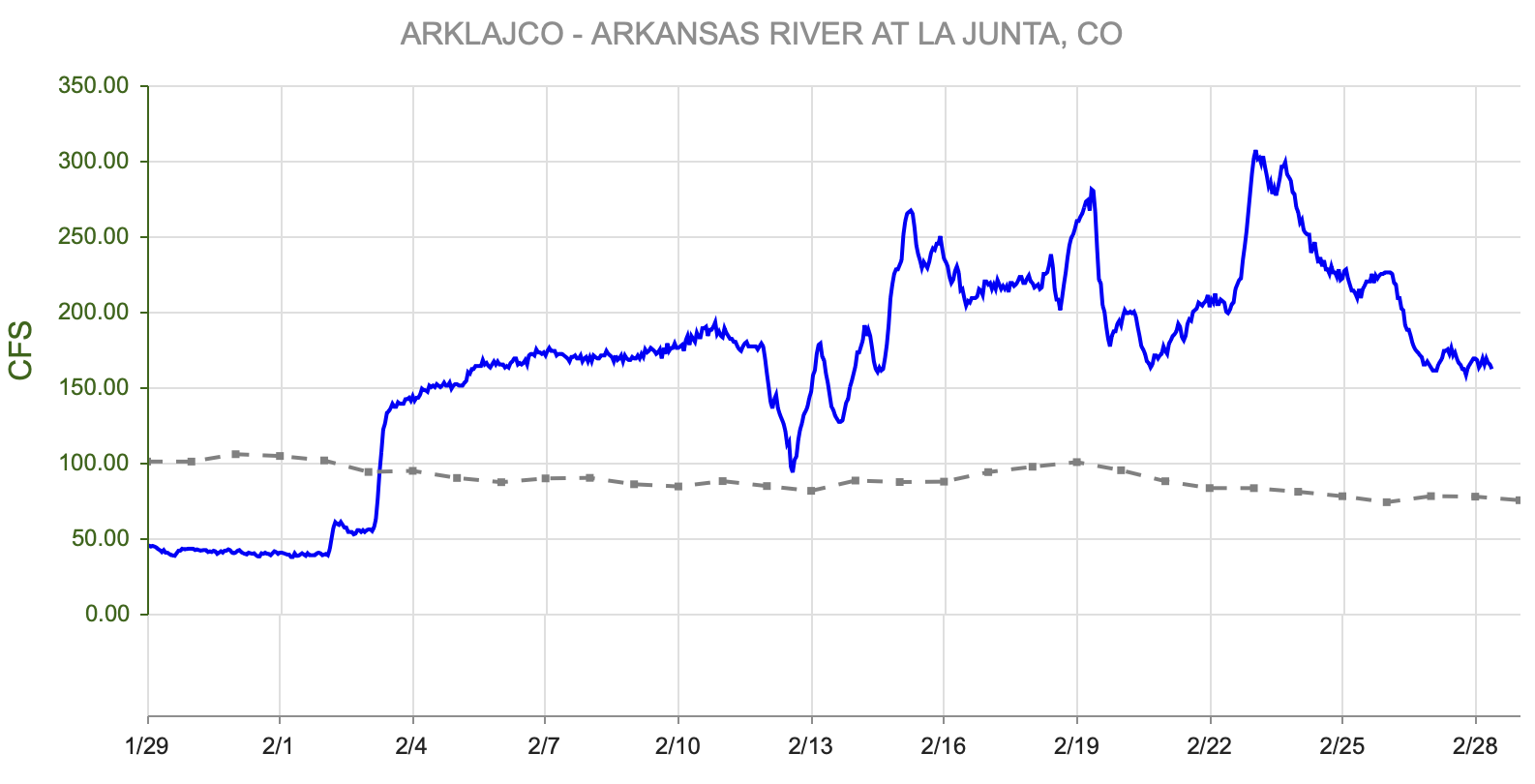
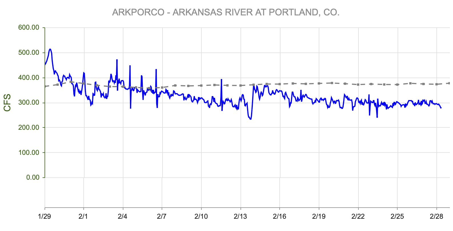
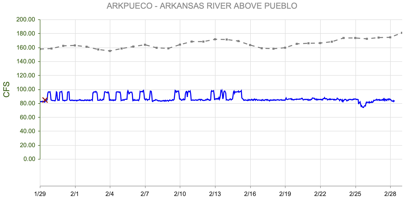
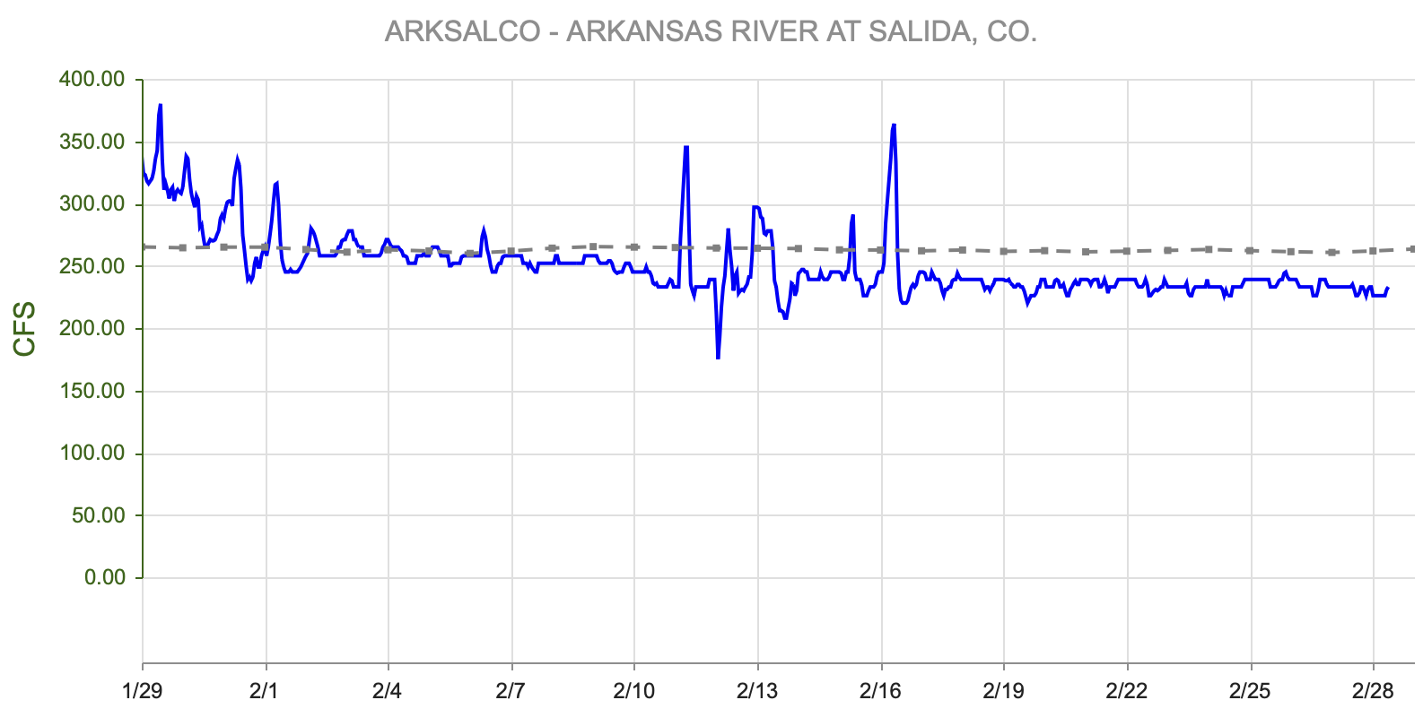
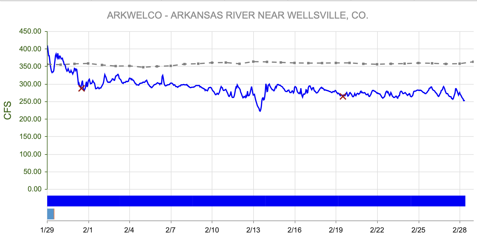
figure 11: Streamflow Summaries Compared to Historical Medians
River Flow Snapshot (3/3/2025, 7:15am)*
* measured flow totals include native flows, BOR project water, releases, and exchanges

figure 12: Map of river gauges in the Arkansas River Basin

figure 13: Arkansas River Flows Upstream to Downstream Viewer
- Granite, CO (8 miles south of Leadville)- 81 cfs
- Salida, CO- 231 cfs
- Wellsville, CO- 270 cfs
- Portland, CO (10 miles south of Canon City)- 285 cfs
- Above Pueblo Reservoir, CO- 84.8 cfs
- Avondale, CO- 338 cfs
- Lamar, CO- 15.2 cfs
For current streamflow updates, reference the Colors of Water webpage.
Reservoir Storage

figure 14: Colorado’s Reservoir Storage Compared to Median
Forecast
There are 5-8 weeks remaining in the typical snow season in the mountains, depending on your location. March doesn’t always bring the steady snowfall expected in mid-winter, but it often delivers a major storm or two. The last week of February has been unusually warm across Colorado with little snow, and the first few days of March will follow the same trend. However, the weather pattern is expected to shift, with storms likely to hit March 3-4, and potentially another round on March 6-7. These storms could intensify the north-south precipitation divide, with the northern mountains and eastern plains getting more snow, while the southern regions may receive less.
If La Niña conditions remain in place, or its effects linger, La Niña typically brings above-average snow to the northern mountains and less to the south. However, this La Niña event is forecasted to be weaker and may not produce the usual winter impacts. The National Weather Service’s Three Month Outlook very much reflect La Nina persisting into the spring (figure 15, figure 16).
The overall outlook for March shows only a small chance of below-average precipitation in southern Colorado. Looking at the spring forecast (March-May), drier conditions are predicted across the state, particularly in the southwest. While northern Colorado is cautiously optimistic about snow and water resources, there are growing concerns about worsening drought in the southern and western parts of the state.

figure 15: Three Month Temperature Outlook

figure 16: Three Month Precipitation Outlook
Want to Learn More? Check out these resources below!
Monitoring
Drought Monitoring: US Drought Monitor
Drought Forecast: National Weather Service Climate Prediction Center
Precipitation Totals: Community Collaborative Ran, Snow, and Hail Network’s Precipitation Mapping System.
Snowpack: Natural Resources Conservation Service
Winter Water Storage System (only applicable until march): Southeastern Colorado Water Conservancy District
Precipitation: https://www.cocorahs.org/
Arkansas River Daily Report – http://www.div2waterops.com/dailyreports
Wind: Windy
Snow Survey and Water Supply Forecasting: Natural Resource Conservation Service Snow Survey
Additional monitoring resources:
Colorado Water Conservation District/Department of Natural Resources
Definitions
30 Year Running Average: When we present the monthly flows, we compare them to that month’s median flows from the last 30 years (referred to as 30 year running average).
Reservoir Percent Full: The Bureau of Reclamation considers a reservoir “full” when pool elevation is at the top of the active conservation pool. Percentage is therefore based on total reservoir volume below that level.
Authorized Diversion: An authorized diversion is NOT A CALL, but a notice that one (or more) diversion structures are subject to a call have been authorized to divert water against the call. These types of diversions are only authorized when the diversion will not affect the downstream call. This type of diversion could occur due to a localized event, such as precipitation diurnal patterns (labeled futile diversion or localized event)
Nonconsumptive call: A call by a diversion that consumes no water (ex. Hydropower, in-stream flow water management).
Futile Call: A situation in which a junior water right holder is allowed to continue to divert in spite of a downstream senior call when curtailing the junior would not produce any additional water for the senior.
For more information on calls, reference the Colorado Division of Natural Resources Administrative Call Standard document.
Educational Resources
Administrative Call Explained: DWR
Citizen’s Guide to Colorado Water Law: CFWE Education
Non-Attorney’s Guidebook to Colorado Water Courts: Co State
Voluntary Flow Management
- https://arkvalleyvoice.com/ahra-says-arkansas-river-flows-are-high-and-fast-making-safety-paramount/
- https://coloradotu.org/arkansas-river
U.S. Climate Normals: https://www.ncei.noaa.gov/products/land-based-station/us-climate-normals