Arkansas River Report for August 2024
Drought and Precipitation
According to the most recent U.S, Drought Monitor report, most of the Arkansas River Basin is abnormally dry or drought free, with moderate drought only along the Kansas-Colorado (figure 1).
Statewide, drought remains on the northern Front Range, which experienced an extremely dry May-July season with multiple wildfires. The Western slopes and Northeastern plains have had above average precipitation, while the Southeastern region has been drier than average. The Arkansas River Basin’s precipitation totals for this water year are at 109% of the median (figure 2).
For the month of August, the CWCB August Water Conditions Committee reported that this month has brought healthy monsoonal patterns, with precipitation well within the upper range of historical variability (figure 3).

figure 1: US Drought Monitor (8/29/2024)

figure 2: Water year to date precipitation compared to 30 year median

figure 3: August 2024 percent of normal precipitation through August 26th
The National Weather Service’s Three Month Outlook predictions are leaning above-normal temperatures and leaning warmer/drier conditions in the Arkansas River basin through November (figure 4; figure 5). These models are based on a predicted shift to La Niña. During La Niña cycles, Colorado typically sees dry falls and snowy winters.


figure 4: Three month temperature outlook
figure 5: Three month precipitation outlook
August Precipitation Totals
In the Arkansas River basin, the Colorado Climate Center reports the following total precipitation amounts, in inches for the month of August in the Arkansas Basin (ranges indicate variability across stations):
Leadville – 2.15-2.76″
Buena Vista -1.79-2.36″
Salida – 0.76- 2.52”
Cañon City – 1.60”
Walsenburg – 1.30-1.71”
Trinidad – 1.52- 2.40”
Pueblo – 0.98-1.60”
Westcliffe – 1.41-1.52”
Colorado Springs – 2.47-4.26″
Rocky Ford – 0.95”
Lamar-0.88-1.96”
River Flows
August Flows Compared to Median
*30 year running avg


River Flow Snapshot (8/3/2024,12:00pm)*
* measured flow totals include native flows, BOR project water, releases, and exchanges
- Empire Gulch, CO (8 miles south of Leadville)- 1190 cfs
- Salida, CO- 455 cfs
- Wellsville, CO- 506 cfs
- Portland, CO (10 miles south of Canon City)- 419 cfs
- Above Pueblo Reservoir, CO- 610 cfs
- Avondale, CO- 742 cfs
- Granada, CO- 426 cfs
For current streamflow updates, reference the Colors of Water webpage.
Reservoir Storage
|
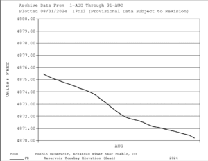
figure 12: Pueblo Reservoir August elevation
|
figure 13: Pueblo Reservoir Storage Allocations
|

|
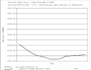
figure 14: Twin Lakes Reservoir August Elevation
|
figure 15: Twin Lakes Reservoir Allocations
|

|
figure 16: Turquoise Lake August elevation
|
figure 17: Turquoise Lake Storage Allocations
|
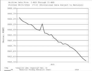

Reservoir Storage Snapshot (9/3/2024, 12:00pm)
- Pueblo Reservoir-
- Pool Elevation: 4,869.7 Feet
- Reservoir Storage: 201,254 Acre-Feet
- 62.3 % Full*
- Reservoir Flood Control Pool: filled 0.0 %
- Turquoise Lake-
- Pool Elevation: 9,865.4 Feet
- Reservoir Storage: 122,318 Acre-Feet
- 94.5 % Full*
- Reservoir Flood Control Pool: filled 0.0 %
- Twin Lakes Reservoir-
- Pool Elevation: 9,192.1 Feet
- Reservoir Storage: 120,341 Acre-Feet
- 85.3 % Full*
- Reservoir Flood Control Pool: filled 0.0 %
Calling Water Rights
Active Administrative Calls Snapshot (9/3/2024, 12:00pm)
The current calling rights are:
1860, Hardscrabble Ditch, Hardscrabble Creek.
1862, Canon Heights Ditch, Fourmile Creek.
1864, Lewelling-McCormick, Purgatoire River.
1865, H R Steele Sump, Fountain Creek.
1866, Walsenburg Ditch, Cucharas River.
1866, Gonzales Ditch, Apishapa River.
1867, Medina Felipa Ditch, Huerfano River.
1873, Whitman and Mott Ditch, Apache Creek.
1873, Seth Brown Ditch, Stout Creek.
1881, Dotson Ditch No. 1, Saint Charles River.
1883,Cameron Ditch, North Fork South Arkansas River.
1882, Tennessee Ditch, South Arkansas River.
1886, Lamar Canal, Arkansas River Mainstem.
1887, Hyde Ditch, Arkansas River Mainstem.
1949, Arkansas River Compact, Arkansas River mainstem.
The authorized diversions are:
1889, Welton Ditch, Huerfano River.
1891, Sunnyside Park Ditch, Arkansas River mainstem.
1904, Dell Ditch No. 1, Currant Creek.
1907, Joseph Dunn Ditch, Lake Fork.
1908, Teller Reservoir, Turkey Creek
1911, Plum Creek Ditch, Plum Creek.
1912, New Salida Ditch, Arkansas River mainstem.
1907, Joseph Dunn Ditch, Lake Fork.
1912, Rock Creek Ditch, Rock Creek.
1912, Lake Creek Ditch, Lake Fork.
The Futile Call is:
1948, Almstrum Ditch, Thirtyone Mile Creek.
Rachel Zancanella Q&A
For this river report, I (Cecilia, ARWC’s Watershed Resources Intern) spoke with Rachel Zancanella, Division 2’s water engineer, to discuss why CWCB is planning on phasing out of “futile calls” and how this will affect water rights holders.

1. What do you want the general public to better understand about water management decisions within the basin?
The nature of an over-appropriated basin is that it is a limited resource, there isn’t enough to go around so in order to make new uses of the water, another use has to be removed.
2. As the division engineer for the Ark basin, what are the decisions you’re making and how are you making them?
On a daily basis we are working to ensure that senior water rights holders and Kansas are receiving the water they are entitled to. In order to do that, we have to make tough decisions that some water users cannot divert and we shepherd that water to those with a legal entitlement to use the water. We consider the priorities of water rights and other requirements for water operations specified in decrees of the court.
3. How does water management on the Upper Ark differ from the rest of the basin and the state of Colorado?
Water in the Upper Arkansas is in connection with the rest of the basin, and principles of water administration, outside of specific Arkansas River Compact requirements, are the same throughout Colorado. The Arkansas basin as a whole is under much more pressure than other areas of the state because it receives so much less water but still has a lot of uses.
4. You spoke in Chaffee County this spring about the move to phase out “futile calls” in the Arkansas Basin, possibly before the start of the 2025 irrigation season.”
a) First, what is a futile call?
Traditionally, when a stream had a dry section between a junior upstream water right and a senior downstream water right, the junior water right would be allowed to take water out-of-priority because efforts to shepherd the water to the downstream senior were considered “futile”.
b) Why is this move being considered?
Today, we recognize that the water doesn’t just disappear from the system in most cases, it just flows under the surface of the ground. It may be delayed in getting to the senior, but it still gets there. In a basin like the Arkansas where there is always a downstream call, the water that disappears underground and resurfaces later will still be subject to a downstream call days or months from now. Similarly, in the Arkansas River basin, groundwater use through wells also must account for their delayed depletions to streamflows. The depletions from a well may be owed to the river even years in the future and those well users still have to protect the seniors from injury by providing a replacement source of water for the senior water rights.
c) What is the status of this move?
Staff and I have been working through the list of water rights we contacted because we knew they were relying on a futile call, evaluating them individually. I have done some field inspections of different scenarios. In some limited cases, they will be able to continue diverting under a futile call, at least in some conditions, because there are hydraulic barriers to flow that separate their uses from the administered system. We’ll document that with the research and conditions for their file. In other cases, we will help the water users understand what their obligations are to continue in a way that is protective of senior rights, for example, augmenting their depletions.
5. How will it affect water rights holders?
Some water users will just have their use under a futile call documented with a better understanding of when they can divert legally, which may be less often, and how to do their diversion records etc. Some others will need to work towards compliance plans in order to divert legally.
6. Looking forward to August and the next three months, what are you paying attention to for the rest of this summer and early fall?
With the run-off behind us we have more ability to focus on records and accounting. We have been working on a Pond Pilot Project in Custer County that has been going really well that we’d like to see wrap up. Typically in the fall we turn our focus to gearing up for our Compact reports which take a lot of time to compile.
Rachel also wanted to share links to more resources and information here:
Publicly available “Beginner’s guides”:
Official videos for the public:
“Who We Are” video.
“Why DWR’s work is vital for Coloradans”
“Colorado’s Water Priority System and DWR’s Water Commissioners’ Role”
“Water Information for Real Estate Agents”
Want to Learn More? Check out these resources below!
Monitoring
Drought Monitoring: US Drought Monitor
Drought Forecast: National Weather Service Climate Prediction Center
Precipitation Totals: Community Collaborative Ran, Snow, and Hail Network’s Precipitation Mapping System.
Snowpack: Natural Resources Conservation Service
Winter Water Storage System (only applicable until march): Southeastern Colorado Water Conservancy District
Precipitation: https://www.cocorahs.org/
Arkansas River Daily Report – http://www.div2waterops.com/dailyreports
Wind: Windy
Snow Survey and Water Supply Forecasting: Natural Resource Conservation Service Snow Survey
Additional monitoring resources:
Colorado Water Conservation District/Department of Natural Resources
Definitions
30 Year Running Average: When we present the monthly flows, we compare them to that month’s median flows from the last 30 years (referred to as 30 year running average).
Reservoir Percent Full: The Bureau of Reclamation considers a reservoir “full” when pool elevation is at the top of the active conservation pool. Percentage is therefore based on total reservoir volume below that level.
Authorized Diversion: An authorized diversion is NOT A CALL, but a notice that one (or more) diversion structures are subject to a call have been authorized to divert water against the call. These types of diversions are only authorized when the diversion will not affect the downstream call. This type of diversion could occur due to a localized event, such as precipitation diurnal patterns (labeled futile diversion or localized event)
Nonconsumptive call: A call by a diversion that consumes no water (ex. Hydropower, in-stream flow water management).
Futile Call: A situation in which a junior water right holder is allowed to continue to divert in spite of a downstream senior call when curtailing the junior would not produce any additional water for the senior.
For more information on calls, reference the Colorado Division of Natural Resources Administrative Call Standard document.
Educational Resources
Administrative Call Explained: DWR
Citizen’s Guide to Colorado Water Law: CFWE Education
Non-Attorney’s Guidebook to Colorado Water Courts: Co State
Voluntary Flow Management
- https://arkvalleyvoice.com/ahra-says-arkansas-river-flows-are-high-and-fast-making-safety-paramount/
- https://coloradotu.org/arkansas-river
U.S. Climate Normals: https://www.ncei.noaa.gov/products/land-based-station/us-climate-normals