Temperature Trends
As we often see for Colorado, April 2025 in Colorado’s Arkansas River Basin saw warm spells interspersed with brief cold snaps. The first half of the month had several unseasonably warm days, while a late-season cold front in the third week brought cooler temperatures and some snowfall to higher elevations.
Throughout the month, daytime highs generally ranged from the 50s to 60s °F, while nighttime lows were mostly in the 30s to low 40s °F—slightly warmer than average for April (figure 1). The cold front mid-month dropped daytime highs temporarily into the 40s, especially in the upper basin, and nighttime lows dipped into the 20s °F in some areas.
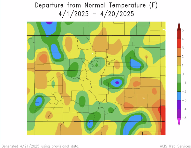
figure 1: Colorado’s April temperatures’ departure from normal (30-year running avg.)
Where does this leave us for our current water year? Colorado is currently tied for the 21st hottest first 5 month in the past 130 years (figure 2).
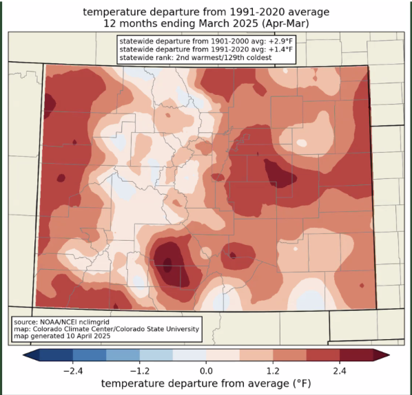
figure 2: Colorado’s 12 Month Temp Ranking
Drought & Snowfall
As of late April, drought conditions persist across the Arkansas River Basin, with nearly all of the region categorized as either abnormally dry or in moderate drought, per the U.S. Drought Monitor (figure 3). Conditions have slightly worsened from March, especially in the southeastern portions of the basin.
Despite the ongoing drought, the water year precipitation total remains above average in parts of the basin, largely due to the November snowstorm. However, April brought only light to moderate precipitation, insufficient to reverse the drying trend. While some isolated snow showers occurred mid-month, southeastern Colorado remained relatively dry.
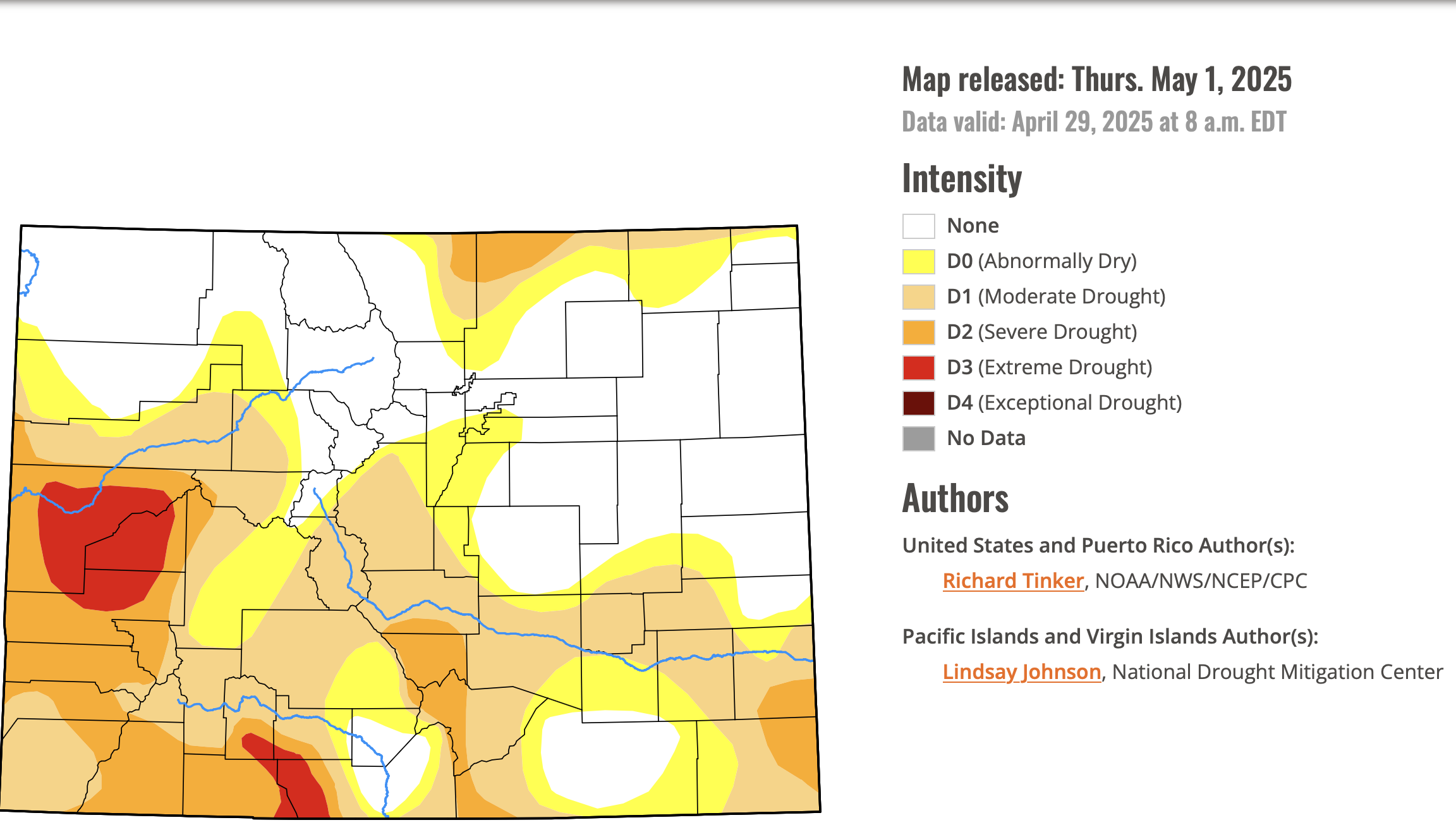
figure 3: Colorado May 1st Drought Monitor
April brought a sharp decline in snowpack across Colorado, with the Arkansas River Basin dropping to just 38% of median—part of a statewide trend that saw record low Snow Water Equivalent (SWE) levels. Warm temperatures in late March triggered early snowmelt, with peak SWE occurring April 8. While elevation influences how long snowpack lingers, snow density now plays a key role as snowpacks go isothermal and prepare to melt out. The Arkansas Basin did see some benefit from a mid-April snowstorm, but it’s not enough to offset a dry early winter and a fast-warming spring (figure 4; figure 5; figure 6).
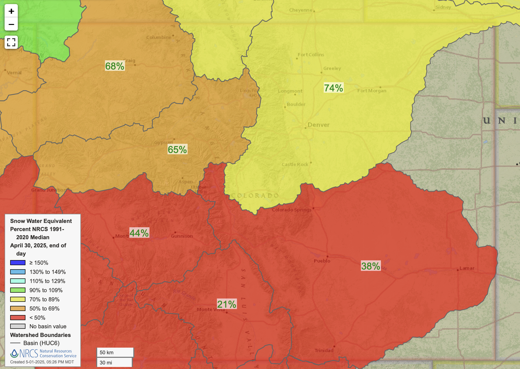
figure 4: Colorado’s Water Year-to-Date Precipitation Percent of Median
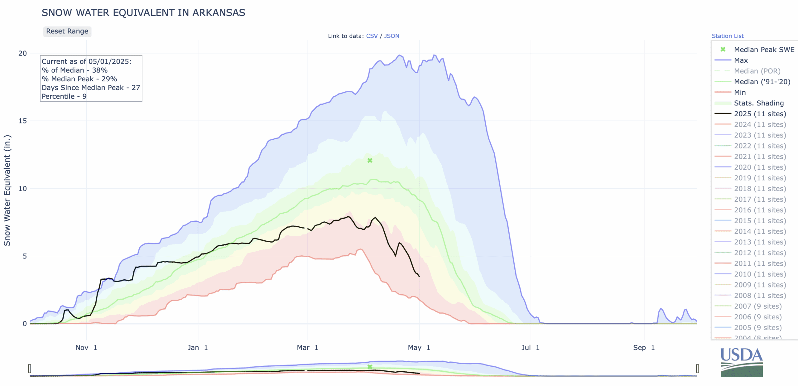
figure 5: Snow Water Equivalent in the Arkansas River Basin
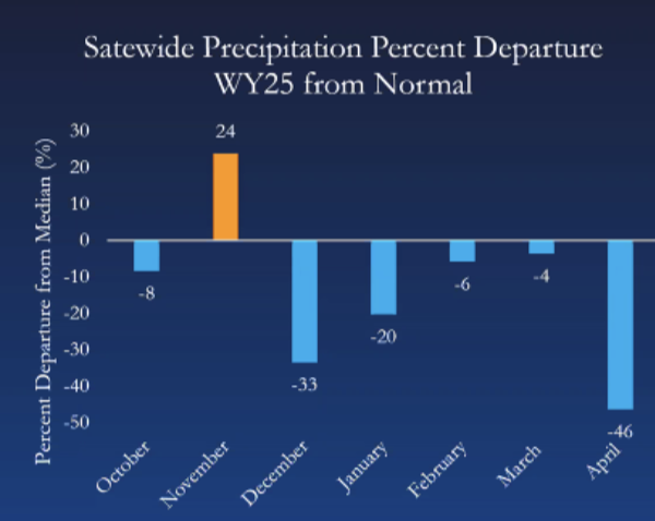
figure 6: Colorado precip percentage departure from normal by month
Streamflow
April river flows were around average or slightly below average for this time of year in the Arkansas River Basin, but expected to pick up significantly into may as the snow melts (figure 7).
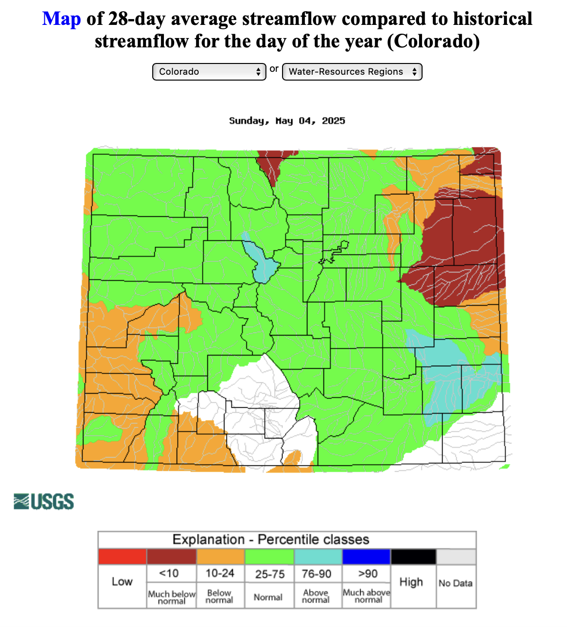
figure 7: Map of 28-day average streamflow compared to historical median
River Flow Snapshot (5/5/2025, 10:45am)*
* measured flow totals include native flows, BOR project water, releases, and exchanges

figure 8: Map of river gauges in the Arkansas River Basin
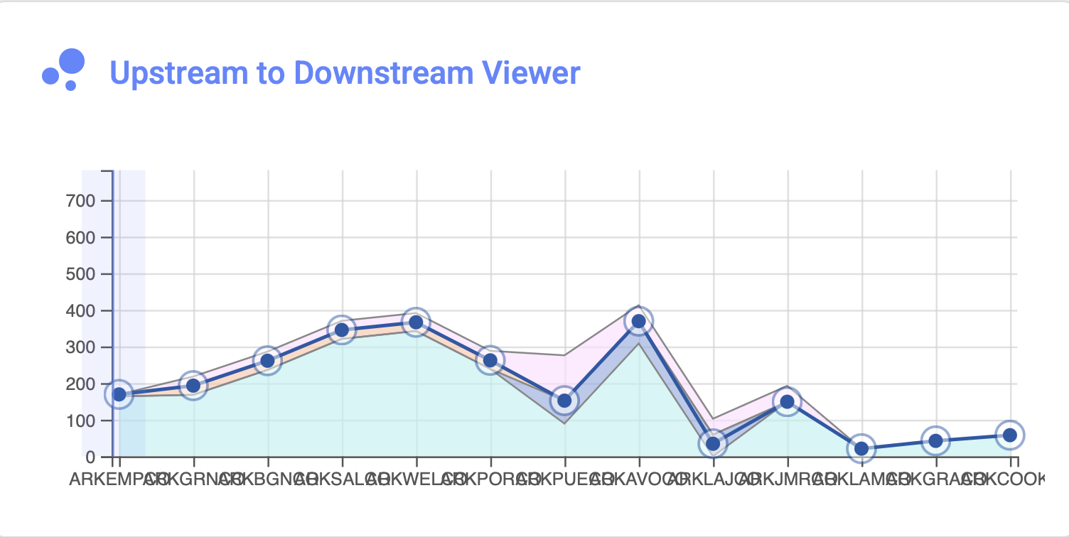
figure 9: Arkansas River Flows Upstream to Downstream Viewer
- Granite, CO (8 miles south of Leadville)- 175 cfs
- Salida, CO- 300 cfs
- Wellsville, CO- 305 cfs
- Portland, CO (10 miles south of Canon City)- 252 cfs
- Above Pueblo Reservoir, CO- 152 cfs
- Avondale, CO- 352 cfs
- Lamar, CO- 22.2 cfs
For current streamflow updates, reference the Colors of Water webpage.
Reservoir Storage
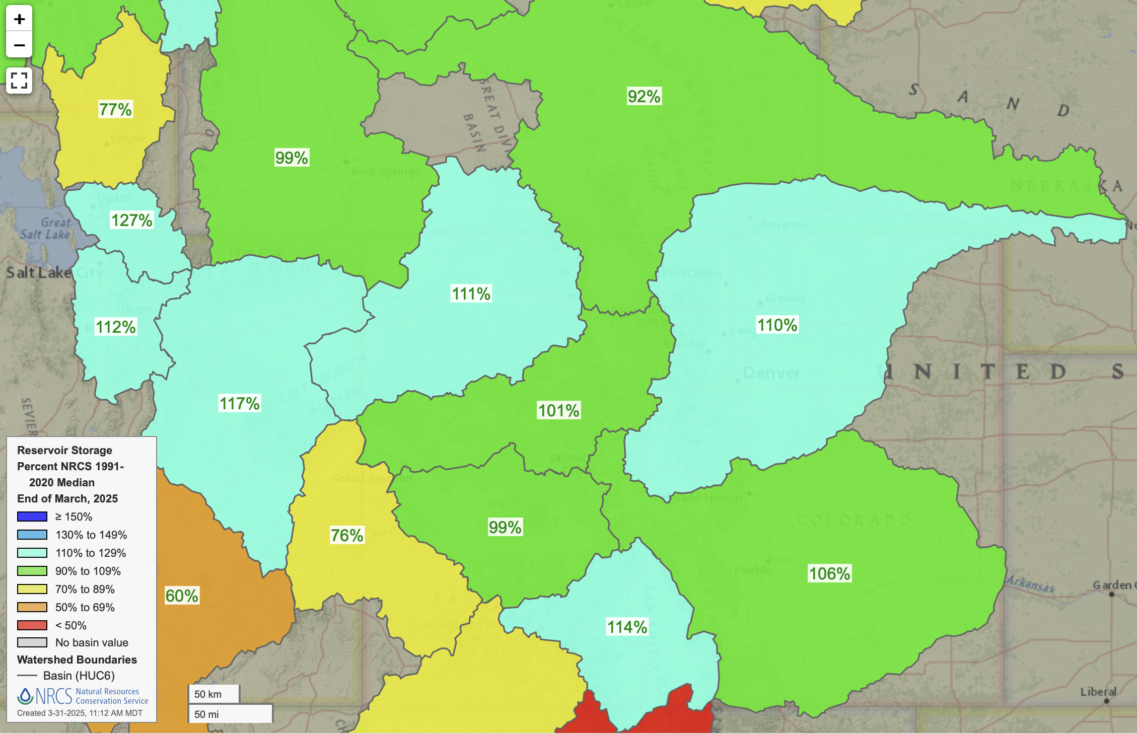
figure 10: Reservoir Storage Percent of Median
Spring/Summer Outlook
La Niña is officially over, and neutral ENSO conditions have taken its place. However, we may still see some lingering La Niña effects through the spring and into early summer. Typically, La Niña is linked to drier-than-normal spring weather in Colorado and a lower risk of wet extremes statewide (figure 11).
Looking ahead, the early summer outlook shows a strong chance of warmer-than-average temperatures and a lean toward drier-than-normal conditions, especially across northern and eastern Colorado (figure 12; figure 13).
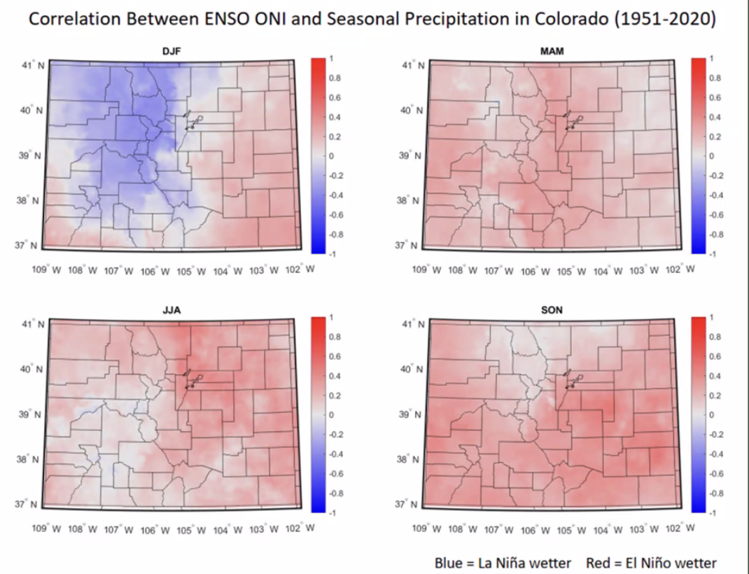
figure 11: Correlation Between ENSO and Seasonal Precip in Colorado
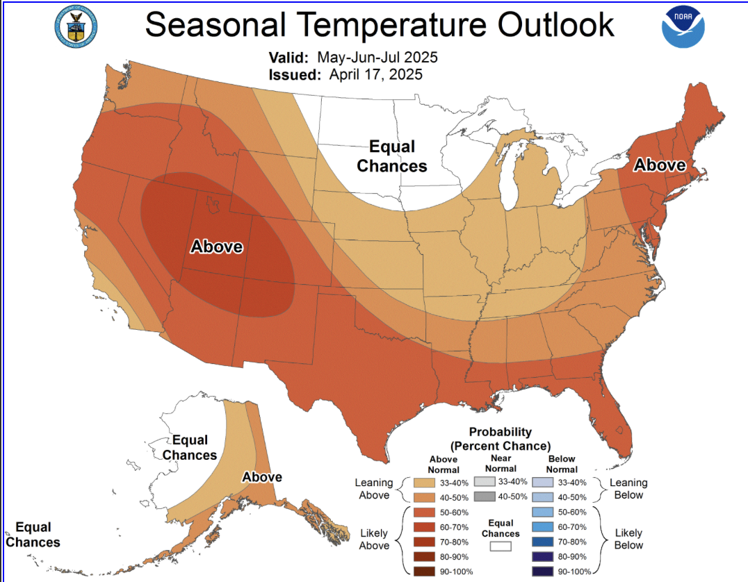
figure 12: Three Month Temperature Outlook
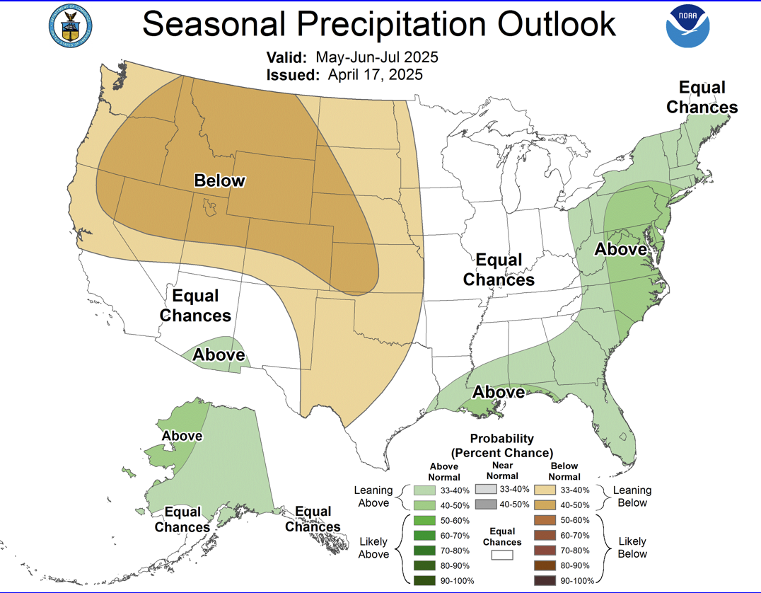
figure 13: Three Month Precipitation Outlook
Wildfire Outlook
While Colorado’s typical wildfire season runs from May through September, wildfires can occur at any time of year. From 2011 to 2022, the state averaged 5,618 wildfires annually, burning approximately 237,500 acres each year. Wildfire is a natural part of Colorado’s ecosystem, but the combination of vast wildlands and expanding communities means that even smaller fires can threaten infrastructure and public safety.
Snowpack helps reduce early-season fire risk, particularly in spring, but its influence wanes by mid-summer. As of this season, snowpack remains well below normal in southwest Colorado—raising concerns about earlier and more intense fire activity in those areas.
Conditions this June point to above-normal wildfire potential for the Four Corners region, largely due to ongoing drought (figure 14). Fires that occur under severe drought conditions are often more destructive and can leave lasting impacts on the landscape, including hydrophobic soils, increased sediment movement, and delayed vegetative recovery.
Check out today’s wildfire risk (figure 15) and the 7-day wildfire outlook using the Colorado Division of Wildfire Protection and Control Wildfire Dashboard.
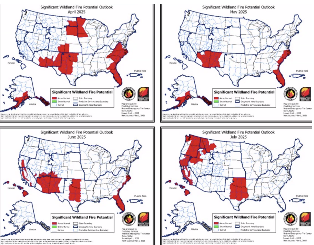
figure 14: Wildfire Risk Outlook Maps
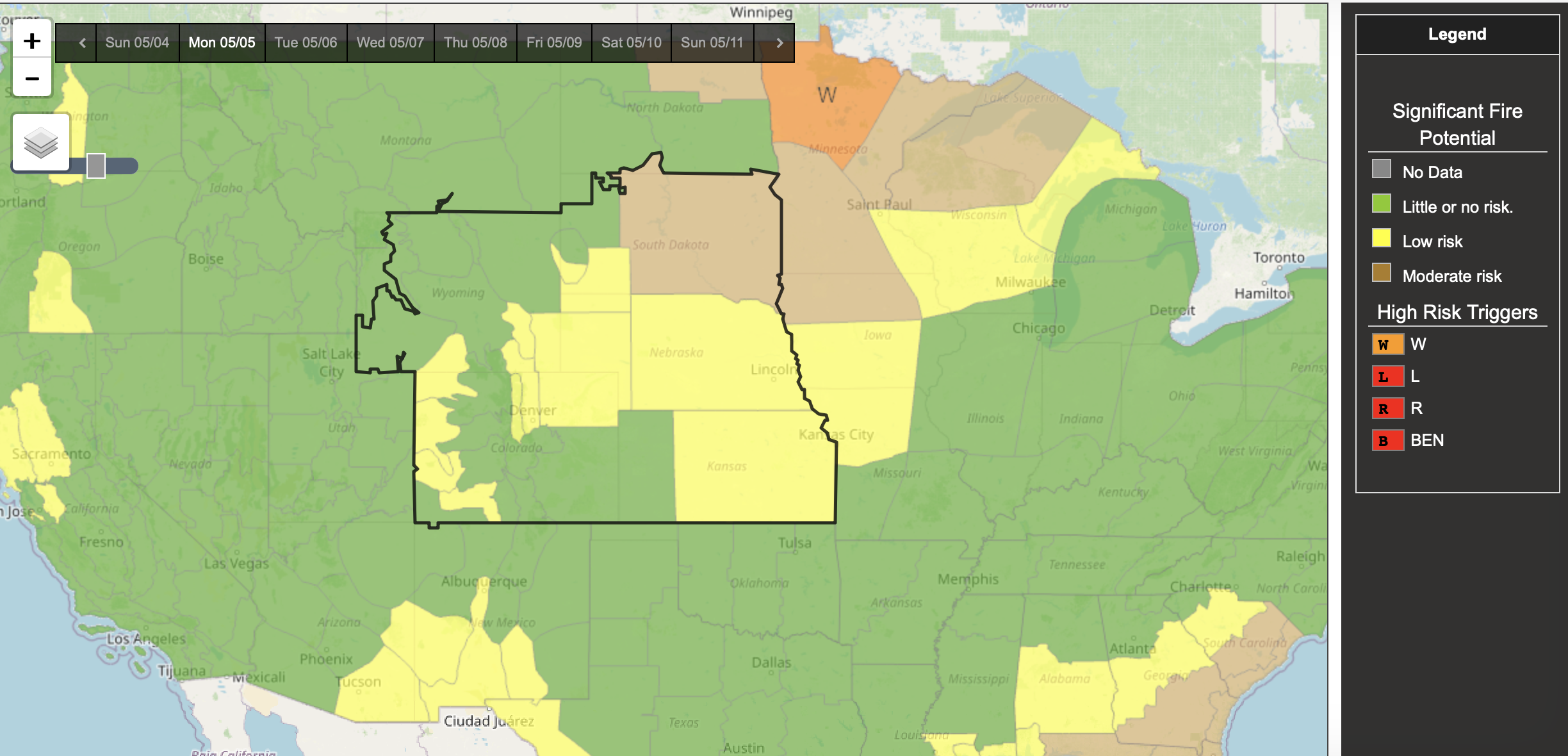
figure 15: May 5th Wildfire risk
Want to Learn More? Check out these resources below!
Monitoring
Drought Monitoring: US Drought Monitor
Drought Forecast: National Weather Service Climate Prediction Center
Precipitation Totals: Community Collaborative Ran, Snow, and Hail Network’s Precipitation Mapping System.
Snowpack: Natural Resources Conservation Service
Winter Water Storage System (only applicable until march): Southeastern Colorado Water Conservancy District
Precipitation: https://www.cocorahs.org/
Arkansas River Daily Report – http://www.div2waterops.com/dailyreports
Wind: Windy
Snow Survey and Water Supply Forecasting: Natural Resource Conservation Service Snow Survey
Additional monitoring resources:
Colorado Water Conservation District/Department of Natural Resources
Definitions
30 Year Running Average: When we present the monthly flows, we compare them to that month’s median flows from the last 30 years (referred to as 30 year running average).
Reservoir Percent Full: The Bureau of Reclamation considers a reservoir “full” when pool elevation is at the top of the active conservation pool. Percentage is therefore based on total reservoir volume below that level.
Authorized Diversion: An authorized diversion is NOT A CALL, but a notice that one (or more) diversion structures are subject to a call have been authorized to divert water against the call. These types of diversions are only authorized when the diversion will not affect the downstream call. This type of diversion could occur due to a localized event, such as precipitation diurnal patterns (labeled futile diversion or localized event)
Nonconsumptive call: A call by a diversion that consumes no water (ex. Hydropower, in-stream flow water management).
Futile Call: A situation in which a junior water right holder is allowed to continue to divert in spite of a downstream senior call when curtailing the junior would not produce any additional water for the senior.
For more information on calls, reference the Colorado Division of Natural Resources Administrative Call Standard document.
Educational Resources
Administrative Call Explained: DWR
Citizen’s Guide to Colorado Water Law: CFWE Education
Non-Attorney’s Guidebook to Colorado Water Courts: Co State
Voluntary Flow Management
- https://arkvalleyvoice.com/ahra-says-arkansas-river-flows-are-high-and-fast-making-safety-paramount/
- https://coloradotu.org/arkansas-river
U.S. Climate Normals: https://www.ncei.noaa.gov/products/land-based-station/us-climate-normals
